 on August 19, 2012, 7:19 pm, in reply to "Re: wunderground"
187.146.113.21
GOES IR limitations
Posted by Bret B![]() on August 19, 2012, 7:19 pm, in reply to "Re: wunderground"
on August 19, 2012, 7:19 pm, in reply to "Re: wunderground"
187.146.113.21
|
I agree, Daniel, many times the GOES infrared loop makes it look more serious than it really is. That's the main weakness in IR data: it can't see INTO the storm, it can only see the top layer of clouds. It measures the temperatures of the cloud tops, which closely corresponds to height (altitude) of the cloud tops. Cold (high) cloud tops USUALLY correspond to severe convection (thunderstorms), which would then cause heavy rain somewhere below those high cloud tops (the angry red and grey colors in the AVN-formatted presentation: http://www.ssd.noaa.gov/goes/west/epac/flash-avn.html) But later in the life cycle of a thunderstorm complex, the cloud tops are still high and cold but they are then known as debris clouds. These spread way out and make the complex LOOK like it's growing larger. It's really just a lid of high cirrus by then, and there may be no more heavy convection going on inside the complex. But it may still show lots of red on the AVN IR image. So you have to use some judgement: if the loop shows smaller spots within the complex "popping up" into stronger colors (ie, red spots in an orange blob, or grey spots in a red blob), then those are probably active thunderstorms causing rainfall. If the last "popping up" spots stopped popping an hour or two ago, and the blob is spreading its skirts out, it might be on the decline thunderstorm-wise. So, to review: 1. Somewhat compact orange blob with red spots popping up: bad news, especially near the spots. 2. Somewhat compact red blob with grey spots popping up: REALLY bad news, especially near the spots. 3. Any other orange or red blobs: MIGHT be bad news; can't be sure. Here's some picture-worth-100-words examples from today's loop: Note the big blob in the southern Gulf of California (between the tip of Baja and the mainland). Lots of yellow/orange with a core of red: 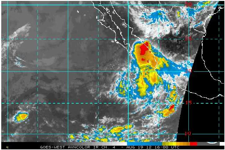 2 hrs later: not much change except for travelling up the coast. Thunderstorms probably exist under the red areas: 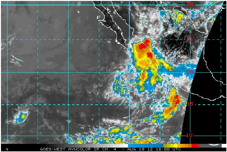 2 hrs later: the original blob offshore has become more static. It might be maturing and calming down. However a new blob has budded off and is moving to the north as it develops: 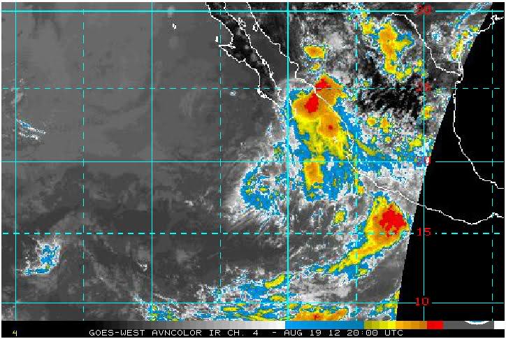 2 hrs later: the original blob is fading quickly, but the new blob has collided with some smaller rapidly developing blobs over the mountains inland from the coast. The collision has fired up a great example of a young large red blob with many grey "pop-up" spots within it. Probably there is lots of severe rainfall and lightning under these grey spots, and maybe some of the surrounding red areas also: 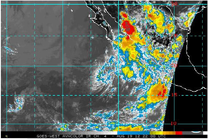 1 hr later (most recent image): still rocking & rolling, but probably not for much longer. It's becoming mature. Some of the red may just be high cirrus debris cloud by now: 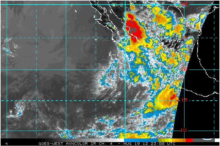 Here's a ground-based weather radar image from Guasave, Sinaloa, taken about the same time as the last GOES image. You can see there is some light to moderate widespread showers, with some heavier showers north of the center (probably thunderstorms). These heavier showers correspond roughly with the grey spots from the last GOES image, but notice much of the red area is not raining at all: 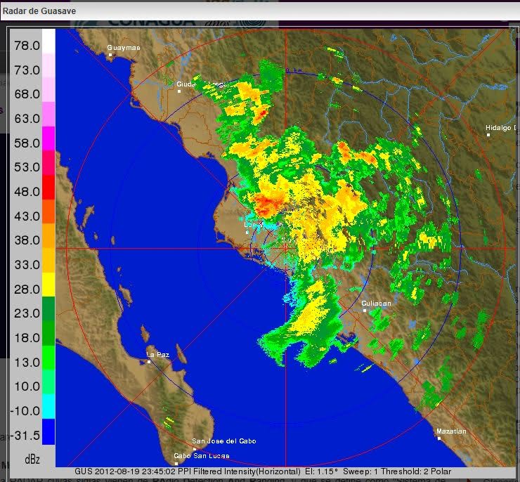 Hope this helps you to squeeze some "ground truth" out of these very remote sensors.... |
| 321 |
|
|
| By posting, you confirm that you have read and Back |
Be sure to visit www.lamanzanilla.info