 on October 21, 2013, 11:56 am, in reply to "Re: TS Raymond"
201.138.180.214
Re: Cat 3 Hurricane Raymond
Posted by Bret B![]() on October 21, 2013, 11:56 am, in reply to "Re: TS Raymond"
on October 21, 2013, 11:56 am, in reply to "Re: TS Raymond"
201.138.180.214
|
In only 24 hrs, Raymond grew from a weak tropical storm to a Category 3 hurricane with 120 MPH winds! Luckily for La Manzanilla, the center will stay well away from us (see 5-day tracking map below.) Right now the eye is almost completely stationary, and is predicted to slowly turn around and head back out to the west after parking for a day or two. The city it will get the closest to should be Lazaro Cardenas, just inside Michoacan near the Guerrero border. So we should get no winds to speak of. It's hard to say how much rain we might get. Raymond is very compact (small diameter), and the heavy rains are so far only near the center. If that stays the case then we might only get a stray blob or two from Raymond's outflow. The poeple in Guerrero who were devastated by Hurricane Manuel a month ago are the most likely to get the heaviest rains from Raymond. They don't need more of that! More about Raymond from The Weather Underground's Dr. Jeff Masters: http://www.wunderground.com/blog/JeffMasters/comment.html?entrynum=2560 Tracking page: http://www.wunderground.com/hurricane/east-pacific/2013/hurricane-Raymond?map=5day 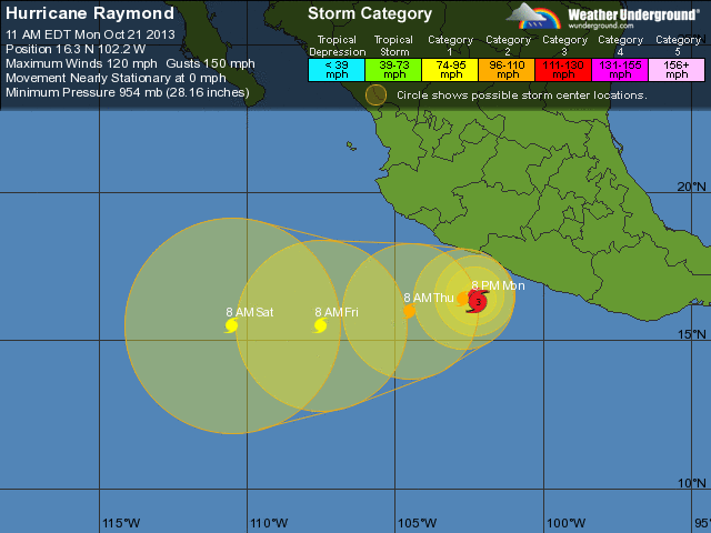 GOES-West IR loop showing spiral bands and obvious eye: http://www.ssd.noaa.gov/goes/west/epac/flash-avn.html TRMM radar satellite showing small area of heavy rains just offshore from Guerrero: http://trmm.gsfc.nasa.gov/trmm_rain/americas/americas_3hrly_zoom.gif |
| 193 |
|
Message Thread
|
|
Be sure to visit www.lamanzanilla.info