Invest 93E: heavier rains this week?
Posted by Bret B  on September 1, 2014, 9:59 am on September 1, 2014, 9:59 am
201.138.182.169-----------------------------Re: Invest 93E: heavier rains this week?
Posted by Bret B on September 2, 2014, 8:39 am, in reply to "Invest 93E: heavier rains this week?"
187.148.187.54
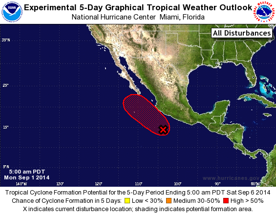
A quick interim report:
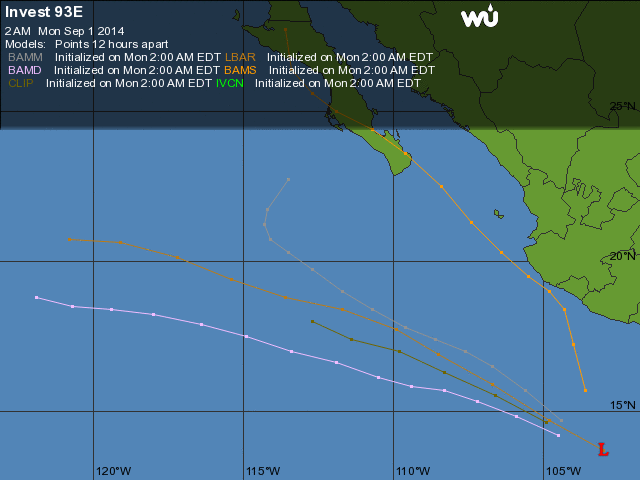
Well the rains started a little early: 2.4" recorded since midnight. Invest 93E should become a tropical cyclone later this morning, and the center is only about 200 miles to our SW. It should get a little closer before its point of closest approach in the next couple days. There will be more detailed predictions later today when the NHC gives it a name. Until then, get ready for more rain...
|
-----------------------------Re: Invest 93E: heavier rains this week?
Posted by john p on September 2, 2014, 9:47 am, in reply to "Re: Invest 93E: heavier rains this week?"
107.193.186.112
love Daniel's beach cam, read your update Bret
thanks ! then clicked on the beach cam and can
see that it is blustery at the beach..good stuff !
|
-----------------------------TS Norbert
Posted by Bret B on September 2, 2014, 1:41 pm, in reply to "Re: Invest 93E: heavier rains this week?"
187.148.187.54
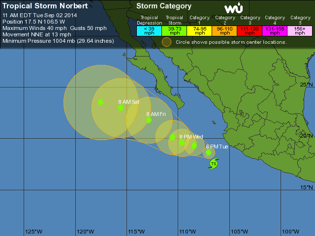
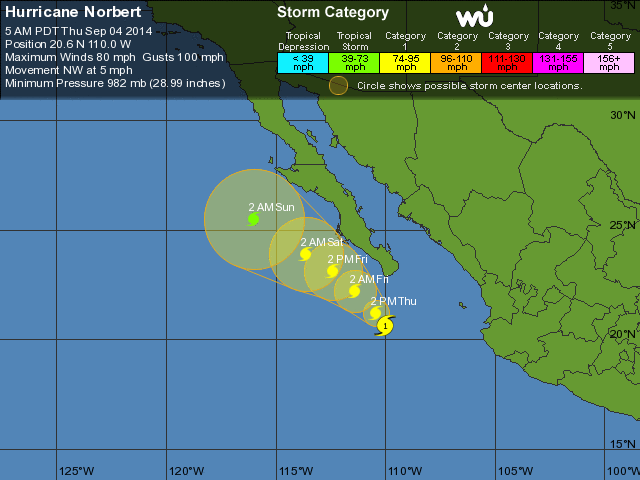
Tropical Storm Norbert just got its name this morning, barely. It's only blowing at 40 mph near the center. At our distance (currently about 170 miles) we shouldn't get more than gusty breezes. Norbert might not make it to full hurricane strength anytime soon.
However, it has plenty of moisture to play with. Our storm total is 2.54" / 65mm so far and I would expect a fair bit more over the next few days. Wunderground's forecast for Barra de Navidad only mentions a 1" accumulation: http://www.wunderground.com/q/locid:MXJO0760 .
The Mexican ConAgua site warns of heavy rain rates of 30mm-60mm (1.2"-2.4") per hour along the Jalisco coast, but they don't mention total accumulations: http://smn.cna.gob.mx/boletin/especial/severo.html.
The US NWS Weather Prediction Center's Caribbean page (also includes Mexico) shows a more detailed (somewhat complicated to interpret) rainfall accumulation prediction for the next week. In this one, we will be on the edge of a heavy rain zone just offshore that peaks at a few inches per 24-hr period: http://www.hpc.ncep.noaa.gov/mike/gfs/crb_p24i_loop_12.html
This site ( http://wxmaps.org/pix/prec3.html ) shows a total accumulation over the next 7 days of 250mm (10"!), centered just offshore of us. This site has not been super-accurate in the past so don't panic about that 10".
Here's the predicted track showing closest approach tonight (maybe 160 miles from us), then turning away from us toward the NW:
http://www.wunderground.com/hurricane/eastern-pacific/2014/Tropical-Storm-Norbert?map=5day
PS, there are NO coastal watches or warnings in effect.
|
-----------------------------Re: TS Norbert - heavy rain
Posted by Bret B on September 3, 2014, 9:35 am, in reply to "TS Norbert"
187.148.187.54
Well, Norbert finally broke our 2-month dry-ish spell! We got 3.22" / 82mm yesterday until midnight in a series of light to moderate showers all day and night long. But then this morning it got quite a bit heavier and we got 4.25" / 108mm since midnight. That's over 1/2" per hour: a respectable rainfall rate. Storm total so far: 7.47" / 190mm!
There's no big change in the paltry few rainfall forecast products I can find out there, except the Weather Underground now mentions 1-2" today, tonight and tomorrow (3-6" more to come?) I would agree that we have at least another day or two of wet weather coming, until Norbert is farther away.
It looks like we'll be closer to reaching that 10" offshore rainfall peak than I would have thought. Be careful out there, especially if you have to drive on Highway 200; expect numerous rockfalls and downed limbs and bad potholes. Stay home until the road gets cleared if you can.
I also don't have any other rainfall reports from Melaque/Barra or Manzanillo. Usually they get a lot more than we do, but maybe this time we are in the "sweet spot."
And how about that cool-down? The outside temperature has hardly changed for the last 24 hours: about 75�F / 24�C. Almost chilly when you add the gusty breezes! Too bad we can't spread this coolness out to cover more of the summer...
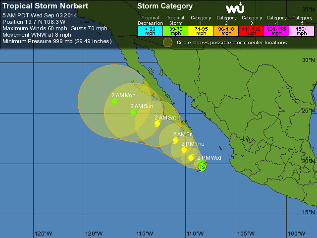
TS Norbert is following its predicted path and is well past us now. It will strengthen up to Cat 1 hurricane strength as is sweeps up the Pacific coast of Baja:
http://www.wunderground.com/hurricane/eastern-pacific/2014/Tropical-Storm-Norbert?map=5day
|
-----------------------------Re: TS Norbert - heavy rain
Posted by sparks on September 3, 2014, 2:47 pm, in reply to "Re: TS Norbert - heavy rain"
187.216.136.10|
I think 10" has come and gone in Melaque. No school today and maybe tomorrow, lagoon was opened, ground is saturated. Hasn't stopped raining since mid day yeaterday
|
-----------------------------Hurricane Norbert - rain report
Posted by Bret B on September 4, 2014, 10:02 am, in reply to "Re: TS Norbert - heavy rain"
187.148.187.54
Norbert is up to Category 1 strength and still heading up toward the west coast of Baja, over 300 miles away from us. But it sure has a long reach to keep sending us rain. We got 7.04" / 179mm yesterday (midnight-to-midnight.) Today so far we got 1.82" / 46mm. So that's 11.82" / 300mm total since Norbert began!
Yesterday's 1-day total is the second highest in my La Manzanilla records (dating back to 2004,) after the 12.24" / 311mm from Hurricane Jova on October 12th, 2011.
And Norbert's storm total so far would be the 4th highest since 2004, behind Helene (2012), Jova (2011) and Invest 95E (2012). I'll update this record after Norbert finally gets done raining on us.
As far as I can glean from my rain forecast products (see previous post on this thread), it looks like we might have one more wet day (today,) and then calming down. Enough already!
Yesterday I saw that the arroyo on the south side of town had breached the beach and was flowing strong and muddy out into the bay. Anyone know if the croc lagoon has breached the beach yet?
Dr. Masters' Norbert discussion on Weather Underground: http://www.wunderground.com/blog/JeffMasters/comment.html?entrynum=2785
http://www.wunderground.com/hurricane/eastern-pacific/2014/Hurricane-Norbert?
|
-----------------------------Re: Hurricane Norbert - rain report
Posted by Daniel Hallas on September 4, 2014, 10:10 am, in reply to "Hurricane Norbert - rain report"
Edited by board administrator September 4, 2014, 10:12 am
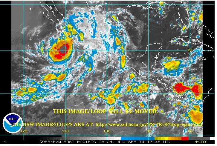
Looking at the Ch4 loop it looks like it may stop soon. There is a semi clear
spot just over the horizon.... The waves came all the way up to the boards I have up by
the office last night!
|
-----------------------------Re: Hurricane Norbert - rain report
Posted by Bret B on September 4, 2014, 12:47 pm, in reply to "Re: Hurricane Norbert - rain report"
187.148.187.54|
Hey Daniel, where did you find that GOES satellite image that splices the GOES-east and GOES-west imagery together? That's a perfect view for our needs here in La Manz. I went to the URL shown in the image but couldn't find this view. I am not worthy...
|
-----------------------------Re: Hurricane Norbert - rain report
Posted by Daniel Hallas on September 4, 2014, 12:59 pm, in reply to "Re: Hurricane Norbert - rain report"
187.148.175.48-----------------------------Croc Laguna
Posted by Mark S. on September 4, 2014, 11:51 am, in reply to "Hurricane Norbert - rain report"
187.146.129.159|
Yes, Bret, the laguna is pouring into the ocean. It's actually probably good that we have such a raging ocean...dilutes the nasty stuff.
|
-----------------------------Re: Hurricane Norbert - rain report
Posted by deanna on September 4, 2014, 2:51 pm, in reply to "Hurricane Norbert - rain report"
187.155.78.168-----------------------------Re: Hurricane Norbert - final rain report & Top 10 rain records
Posted by Bret B on September 6, 2014, 11:55 am, in reply to "Re: Hurricane Norbert - rain report"
187.148.187.54
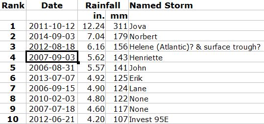
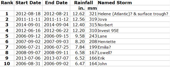
Now that Norbert's rain is over for us, here is the final standings in the La Manzanilla rainfall record books (dating back to 2004):
Norbert's 1-day rainfall of 7.04" / 179mm on Sep. 3 is the second highest, after the 12.24" / 311mm from Hurricane Jova on October 12th, 2011. Here are the Top 10 1-day rainfalls:
Norbert's multi-day storm total of 12.40" / 315mm comes in 3rd place after Helene in August 2012 and Jova in October 2011. Here are the Top 10 multi-day storm totals:
|
-----------------------------
|
|
|
|
|
|
|
|
|
|
|
|
|