Invest 94E: Next storm?
Posted by Bret B  on September 8, 2014, 5:36 pm on September 8, 2014, 5:36 pm
187.148.187.54-----------------------------Re: Invest 94E: Next storm?
Posted by Daniel H on September 8, 2014, 6:13 pm, in reply to "Invest 94E: Next storm? "
187.148.187.232-----------------------------Re: Invest 94E: Next storm?
Posted by Bret B on September 9, 2014, 12:44 pm, in reply to "Re: Invest 94E: Next storm? "
201.138.182.201
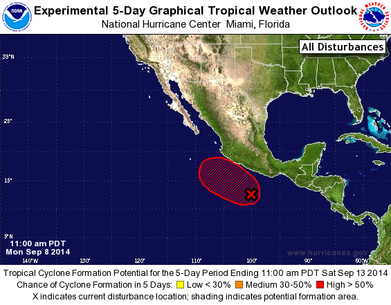
Yeah, my sister in Phoenix said thanks for sending her almost half a year's supply of rain in just a few hours! (Phoenix's average annual rain is about 8".)
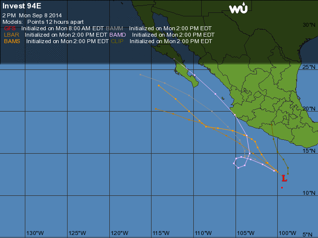
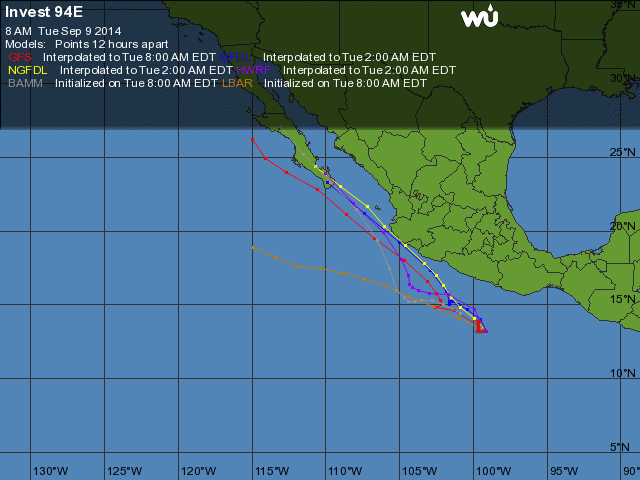
Meanwhile, our next storm Invest 94E is still developing. Up to 60% chance in the next 2 days, and 80% in the next 5 days. And the computer models show it passing pretty close to La Manzanilla maybe around Friday or Saturday. Heavy rains are quite possible later this week.
http://www.wunderground.com/hurricane/east-pacific/2014/invest-94E?map=model
|
-----------------------------Re: Invest 94E: NextWAVEsorm?
Posted by Carol on September 10, 2014, 4:49 am, in reply to "Invest 94E: Next storm? "
31.209.13.69
The tomzap site is reporting that huge waves are moving up the coast, expected to hit on Sat.
Someone may want to check to get the latest info for the beach front homes and residences in La Manz.
|
-----------------------------TS Odile: big rain threat
Posted by Bret B on September 10, 2014, 12:21 pm, in reply to "Re: Invest 94E: NextWAVEsorm? "
201.138.182.201
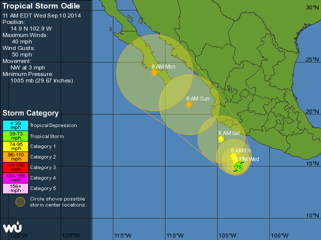
Invest 94E is now Tropical Storm Odile. The predictions show it wandering slowly down south of us for a couple days, then accelerating along the coast just offshore, passing closely by us around Saturday as a Category 1 or 2 hurricane.
But be careful: there is greater than normal uncertainty in these predictions at this point in time. Note the large "error circles" in the tracking map. The center of the storm could end up anywhere in those circles, including inland or out to sea, or right on top of us. It's too early to tell, so take all these forecasts with an appropriately sized grain of salt. There are NO official coastal watches or warnings yet.
http://www.wunderground.com/hurricane/east-pacific/2014/tropical-storm-Odile?map=5day
Big Rain Threat:
Jeff Masters' blog on the Weather Underground shows a computer model of the predicted rain accumulation for the Mexican coastline from Odile (known as TD 15-E briefly this morning.) It predicts us getting 8-16 inches total from the storm. That could be hazardous considering how wet the ground still is after Norbert. Expect plenty of problems on the highway, and especially in Melaque and Cihuatlan.
http://www.wunderground.com/blog/JeffMasters/comment.html?entrynum=2792

Wind Threat:
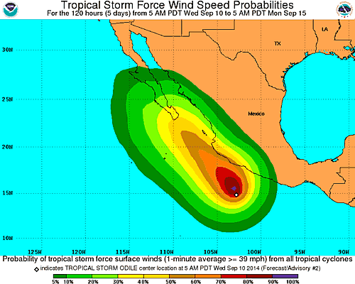
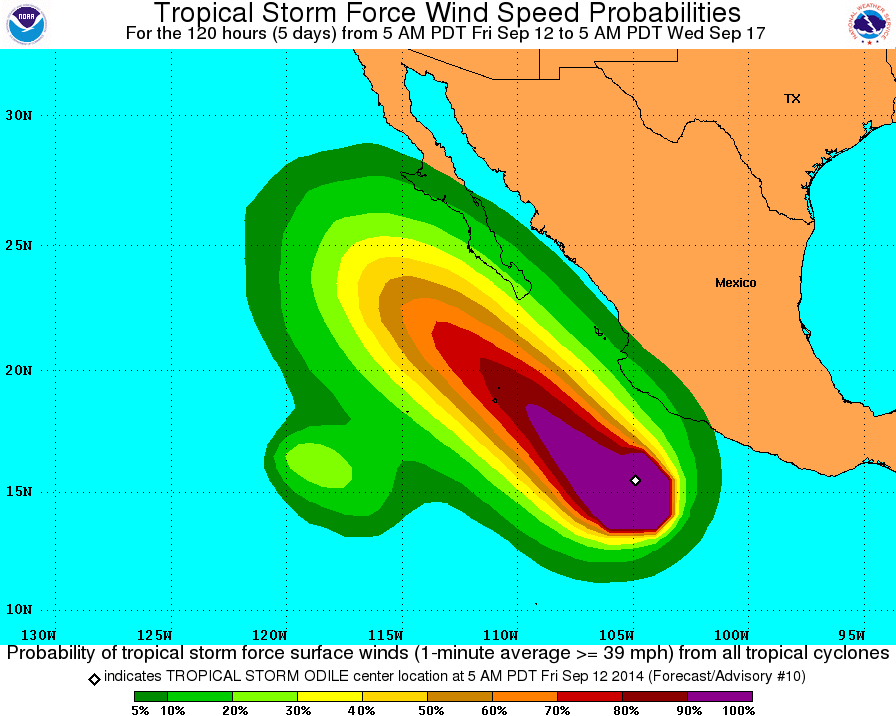
At this early date, the NHC predicts only about 10% chance of us getting hurricane-force winds here in La Manz: http://www.nhc.noaa.gov/refresh/graphics_ep5+shtml/143341.shtml?hwind120#contents
However, they predict about 50-60% chance of us getting tropical storm force winds (>39 mph):
http://www.nhc.noaa.gov/refresh/graphics_ep5+shtml/143341.shtml?tswind120#contents
Surf Threat:
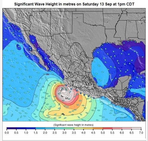
The surf will surely get bigger and more dangerous as Odile passes by. How big? The surf forecast for Boca de Iguanas predicts 7.5-meter (25-foot) waves coming from the SE on Saturday (wow!) La Manz is fairly protected from SE waves, but don't forget about some possible storm surge and high tide levels adding to the wave height. The beach might be dangerous this weekend!
7-day forecast: http://www.surf-forecast.com/breaks/Bocadelos-Iguanas/forecasts/latest/six_day
Wave height graphic for Saturday: http://www.surf-forecast.com/weather_maps/Mexico?hr=84&over=none&type=htsgw
Don't panic yet, but be prepared. Stay tuned!
|
-----------------------------Re: TS Odile: big rain threat
Posted by Jane on September 10, 2014, 12:45 pm, in reply to "TS Odile: big rain threat"
187.148.141.17|
The rule of thumb regarding storm intensity has usually been: When the fishermen take their boats out of the water and park them around the jardin, it's time to be concerned.
|
-----------------------------Re: TS Odile: big rain threat
Posted by Clare on September 11, 2014, 10:20 pm, in reply to "Re: TS Odile: big rain threat"
69.4.63.91
Hi Bret,Do I need to fly back Mananna. Please say yes.Should I call tomorrow. Think I will what ever.
Miss you all. Clare
|
-----------------------------Re: TS Odile: big rain threat
Posted by Bret B on September 12, 2014, 10:30 am, in reply to "Re: TS Odile: big rain threat"
201.138.178.248
Hi Clare! It's great to hear from you. No, I think your casa and the doggies should be fine. But feel free to fly back if you want; we miss you!
We'd love a call anytime, or you can email us with a good time for us to call you from our computer (a lot cheaper.)
|
-----------------------------Re: TS Odile: big rain threat
Posted by Bret B on September 11, 2014, 8:06 am, in reply to "TS Odile: big rain threat"
201.138.182.201
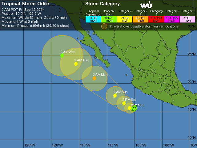
Well, what a difference 24 hours makes: now Odile will stay well offshore as it passes us on Saturday. The intensity and timing are still about the same.
http://www.nhc.noaa.gov/graphics_ep5.shtml?5-daynl?large#contents
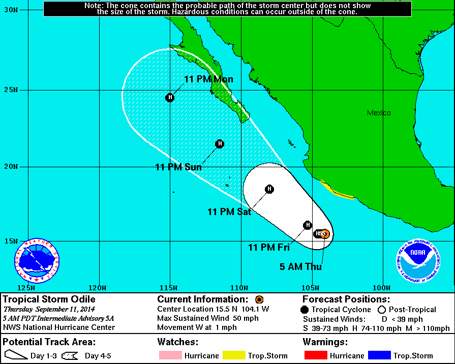
A Tropical Storm Watch has been issued for the Mexican coast from Lazaro Cardenas (southern Michoac�n) up to Manzanillo.
The rain threat should be less than reported yesterday. We could start getting rains anytime now: there is a lot of moisture in our area and it's getting bored.
The wind threat is only a little less (the storm must be getting a little wider.)
And the surf threat is still 7 meters according to that surf forecast site, but extending into Sunday also (see my previous post for links.)
Thanks for the kind words about my weather posts you guys. This is kind of a fun hobby for me, but I appreciate your appreciation!
|
-----------------------------Re: TS Odile: No rain threat?
Posted by Bret B on September 12, 2014, 10:26 am, in reply to "Re: TS Odile: big rain threat"
201.138.178.248
Tropical Storm Odile's predicted path continues to get moved farther offshore from our coast with each new forecast. Now it looks like it will be about 200 miles offshore as it passes by us tomorrow. So it might not bring us much of anything. That's fine with me!
The Mexican government has moved the Tropical Storm Watch; it now extends from Manzanillo to Cabo Corrientes (this includes La Manzanilla.) I'm not sure why though.
http://www.wunderground.com/hurricane/eastern-pacific/2014/Tropical-Storm-Odile?map=5day
Rain: Probably no heavy rains but there is always the chance of a random thunderstorm, directly caused by Odile or not. Like last night's lightning show.
Wind: There is still a 10%-20% chance of us getting tropical storm-force winds (>39 mph) this weekend. It will probably be gusty, breezy and maybe even windy occasionally. http://www.nhc.noaa.gov/refresh/graphics_ep5+shtml/115638.shtml?tswind120?#contents
Surf: still could be a threat. The forecast for Boca is down to 6 meters Saturday night and into Sunday. Less than that here at the more sheltered end of the bay. I don't now if the fishing boats are getting hauled off the beach yet, but the surf threat might be enough.http://www.surf-forecast.com/breaks/Bocadelos-Iguanas/forecasts/latest/six_day
|
-----------------------------Re: Invest 94E: NextWAVEsorm?
Posted by Rob Boyes on September 10, 2014, 12:44 pm, in reply to "Re: Invest 94E: NextWAVEsorm? "
209.52.53.24|
Bret , you are doing an exceptional job of keeping us informed about the storm conditions. I'm sure it is appreciated by the people there and by us who are looking forward to being there and are watching from afar. I hope everything and everyone remains safe. Thanks for your diligence.
|
-----------------------------Bret B.
Posted by Mark S. on September 10, 2014, 1:37 pm, in reply to "Re: Invest 94E: NextWAVEsorm? "
187.146.129.159
Bret does an incredible job of keeping us posted as to coming weather events.
However, he does a poor job of preventing them.
He needs to try harder.
|
-----------------------------Re: Bret B.
Posted by Lisa Fern on September 10, 2014, 1:41 pm, in reply to "Bret B."
187.148.169.117|
Everyone talks about the weather, but no one does anything about it. - Mark Twain
|
-----------------------------Hurricane Odile - mellow so far
Posted by Bret B on September 13, 2014, 2:54 pm, in reply to "Invest 94E: Next storm? "
201.138.178.248
So far we're getting all the good and none of the bad out of Odile: cool, cloudy, calm winds, no rain (just a few sprinkles.) And the waves aren't big yet.
There isn't much new to report since yesterday except Odile is now a Cat 1 hurricane (85 mph winds) and its diameter has increased quite a bit. We are actually under its spiral cloud bands now, but it's been very mellow so far.
Later tonight into tomorrow I would still expect some gusty breezes and occasional rains and some surf (latest forecast is down to 3.5-4.5 meters today and tomorrow AM.) After tomorrow it will be getting farther from us as it heads up toward Baja.
|
-----------------------------Re: Major Hurricane Odile - it finally made it!
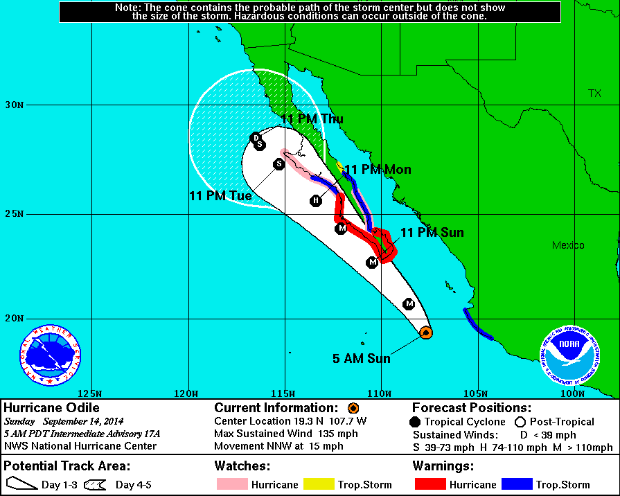
Posted by Bret B on September 14, 2014, 8:40 am, in reply to "Hurricane Odile - mellow so far"
201.138.178.248
Odile is now Category 4 with 135 mph winds at the center, thanks to an episode of "rapid intensification" last night. That makes 7 major hurricanes in the East Pacific so far this season; one shy of the all-time record.
It is past the point of closest approach to La Manz which was about 175 miles late last night. It took a little longer to turn to the northwest last night, so it got closer than predicted by 30-40 miles. That explains some of the sudden onset of the rowdy winds last night. It's still pretty gusty this morning. It's amazing that the power is still on; great job CFE!
And the rain finally got here: 1.44" / 37mm yesterday up to midnight, 2.94" / 75mm today so far. Including Friday's 0.22" / 6mm, the storm total is at 4.60" / 117mm.
According to Daniel's beach cam, it doesn't look like the surf is super-high. It might get worse today before it settles down.
So the worst of the wind is probably past for us, but look out Baja! And we're not out of the rain yet, I'm sure.
http://www.nhc.noaa.gov/graphics_ep5.shtml?5-daynl?large#contents
|
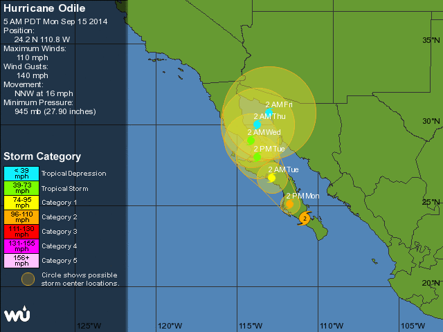
-----------------------------Odile - final rain report
Posted by Bret B on September 15, 2014, 9:44 am, in reply to "Re: Major Hurricane Odile - it finally made it!"
201.138.178.248
Now that Odile is busy lashing Baja and aiming toward my sister in Phoenix, here are our final rain totals from Odile:
Yesterday it rained off and on, sometimes heavily, for most of the day and we got 5.16"/131mm. That ranks #6 in the Top 10 1-day rainfall records.
The storm total was 6.82"/173mm. That puts it #8 in the Top 10 storm total rainfall record. Not too shabby! This month has 2 of the Top 10 records already.
Yesterday afternoon the arroyo on the south side of town was flowing heavily into the bay. Its level was only a couple inches below the original drain from the Jardin by the small concrete bridge. Any damage reports from the rest of the town? Nothing much posted on the Melaue/Barra Tomzap forum.
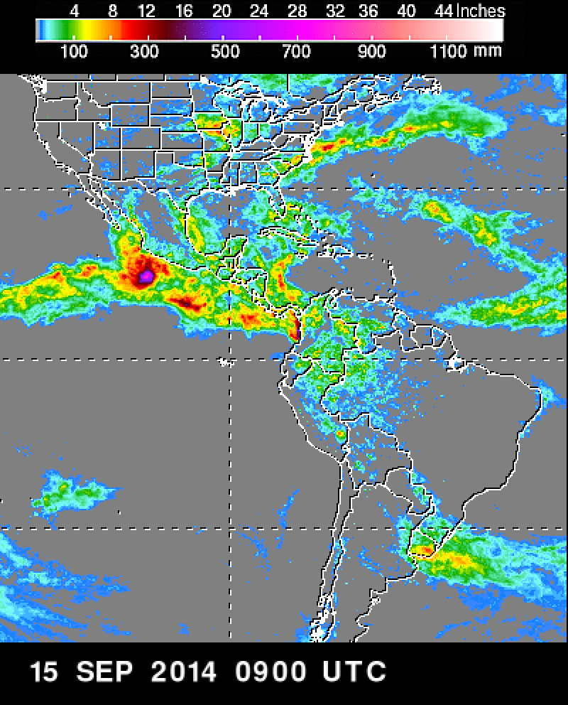
Here is the 1-week rainfall accumulation from the TRMM radar satellite. Aren't you glad we were not in the peak of the rainfall zone? (around 28-30"!)
http://trmm.gsfc.nasa.gov/publications_dir/regional_americas.html
http://www.wunderground.com/hurricane/east-pacific/2014/hurricane-Odile?map=5day
PS, there is already another Invest down in the breeding grounds. I'll keep you posted if it develops more.
|
-----------------------------Re: Odile - final rain report
Posted by Lisa Fern on September 15, 2014, 10:45 am, in reply to "Odile - final rain report"
201.138.182.204|
Hey Bret, can I hang out my laundry yet? Thanks
|
-----------------------------Re: Odile - final rain report
Posted by Bret B on September 15, 2014, 11:28 am, in reply to "Re: Odile - final rain report"
201.138.178.248
Ours is hanging out on the line, but we got an early start and we have the back-up line under the patio roof ready in case it rains today. Just trying to stay ahead of the next storm, whenever that happens...
We just walked up Calle Perula Sur past the Galeria and the Vet to check out that usual spot in this street that likes to turn into a 6-ft deep gully during heavy rains. But surprise! It's only a couple feet deep this time!
|
-----------------------------Re: Odile - final rain report
Posted by Lisa Fern on September 15, 2014, 2:58 pm, in reply to "Re: Odile - final rain report"
201.138.182.53-----------------------------Re: Odile - final rain report
Posted by PerulaPete on September 15, 2014, 11:48 pm, in reply to "Re: Odile - final rain report"
Thanks Bret for the great reports,now all I need to know is my palapa roof still there !
Cheers
|
-----------------------------Re: Odile - final rain report - TRMM satellite dying
Posted by Bret B on September 20, 2014, 9:20 am, in reply to "Re: Odile - final rain report"
187.148.41.119
Regarding Odile's (not Polo's) total rainfall accumulation, here is an analysis by the TRMM satellite people:
http://trmm.gsfc.nasa.gov/
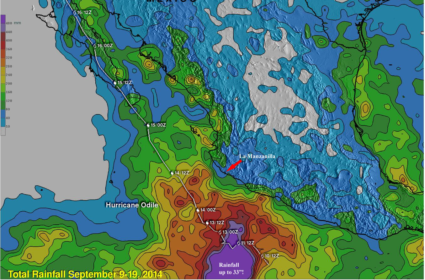
And here's a screenshot of their graphic, showing the area offshore from us that got up to 33" of rain! That's according to the text in their post; the scale of the graphic colors only goes up to 480mm/19".
I annotated La Manzanilla's position with an arrow. At our location, the graphic indicates we got between 40mm/1.6" and 80mm/3.1" of rain, up to 120mm/4.7" just a few miles away. My rain gauge reported 173mm/6.8" from Odile, so there is a bit of a discrepancy in the "ground truth".
Oh well, questions about the TRMM data won't matter soon. (Check the link on their home page: http://trmm.gsfc.nasa.gov/publications_dir/trmm_fuel_status.html) The satellite has run out of maneuvering fuel and is expected to sink lower and lower until it reenters sometime in 2016. They will stop disseminating the various data products as they go out of calibration because of the changing altitude and orbital period. One more satellite I worked on at Motorola back in the '90s bites the dust! 
|
-----------------------------
|
|
|
|
|
|
|
|
|
|
|
|
|
|
|
|
|
|
|
|
|