Invest 92E- possible rains coming?
Posted by Bret B  on October 16, 2014, 6:00 pm on October 16, 2014, 6:00 pm
187.148.142.164
Just when you thought the tropical storm season might have ended for us: this Invest has been trying to get organized down in the breeding grounds for the last several days. I wouldn't sound the alarm on this except that there are some very intense thunderstorm cells flaring up ahead of the center of the Invest as it slowly heads toward the southern Mexico coast. The big blobs are still barely up to the Michoacán coast, but they have been steadily crawling up the coastline today in our general direction. If blobs like these keep coming like this, we might get some rain in a couple days or so.
If your computer can handle Flash animations, the latest GOES-West IR Flash loop shows a couple of big angry blobs coming into view out of the "blacked-out" portion of this satellite's data, on the outskirts of the broad Invest area: http://www.ssd.noaa.gov/goes/west/epac/flash-avn.html
If your computer can still handle Java, here is the secret GOES IR Java loop that Daniel discovered showing the merged data from the GOES-West and Goes-East satellites (no annoying blacked-out portion): http://www.ssd.noaa.gov/PS/TROP/DATA/RT/epac-ir4-loop.html
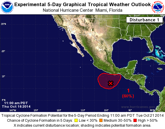
The NHC page says Invest 92E has a 50% chance of developing into a cyclone in the next 2 days, and 60% chance in the next 5 days ( http://www.nhc.noaa.gov/gtwo.php?basin=epac&fdays=5 ):
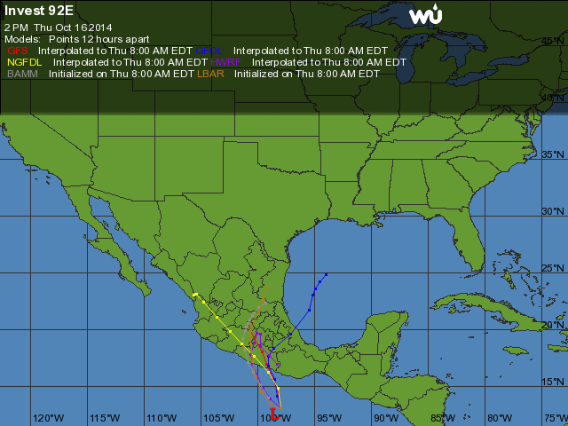
Weather Underground's map of the computer models (remember that these lines are just the storm center's predicted paths. The breadth of the storm isn't shown http://www.wunderground.com/hurricane/east-pacific/2014/invest-92E?map=model http://www.wunderground.com/hurricane/east-pacific/2014/invest-92E?map=model
It's not TOO unusual to have tropical development in October. We're just a few days past Hurricane Jova's anniversary (Oct 11,12 2011.) Since October storms are notoriously erratic, this one bears watching.
(Even Hawaii is being threatened by Tropical Storm Ana in a few days. This is the third storm to threaten or hit them this season: very unusual.)
|
-----------------------------Re: Invest 92E- possible rains coming?
Posted by david c on October 16, 2014, 8:09 pm, in reply to "Invest 92E- possible rains coming?"
75.106.149.200
Tks for the info.
I am presently on the big island awaiting the arrival of the storm here and also thinking of my place in La Manzanilla, which I plan to return to in November, hopefully after the rains stop.
|
-----------------------------Re: Invest 92E- possible rains coming?
Posted by Bret B on October 17, 2014, 9:06 am, in reply to "Re: Invest 92E- possible rains coming?"
187.148.142.164
No big changes in our forecast this morning. The Invest is still behaving somewhat erratically, and is now predicted to aim mostly at southern Guerrero state (Acapulco region.) But it is still throwing some big blobs in our direction. Those blobs are our main rain threat for now. Our chance of rain today is not high, but definitely higher than it has been the last several days.
"Blob loop": http://www.ssd.noaa.gov/goes/west/epac/flash-avn.html
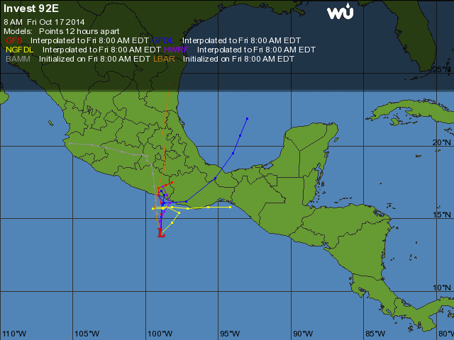
Computer models ( http://www.wunderground.com/hurricane/eastern-pacific/2014/Invest-92E?map=model )
Excerpt from NHC Topical Weather Discussion ( http://www.nhc.noaa.gov/text/refresh/MIATWDEP+shtml/ ):
"...THIS SYSTEM IS EXPECTED TO SHIFT N TO NW DURING THE NEXT FEW DAYS BEFORE MOVING VERY CLOSE TO THE
COAST OF MEXICO. ENVIRONMENTAL CONDITIONS ARE CONDUCIVE FOR DEVELOPMENT OF THIS SYSTEM DURING THE NEXT 48 HOURS...AND IT HAS A MEDIUM CHANCE OF DEVELOPING INTO A TROPICAL CYCLONE (70% next 2 days, 80% next 5 days.) REGARDLESS OF DEVELOPMENT...RAINFALL ASSOCIATED WITH THIS LOW WILL LIKELY AFFECT THE COASTAL STATES OF MEXICO FROM OAXACA TO MICHOACAN FOR THE NEXT FEW DAYS...WITH PERIODS OF VERY HEAVY RAINFALL LEADING TO FLASH FLOODING AND LANDSLIDES POSSIBLE."
|
-----------------------------TS Trudy lands near Acapulco- minimal rain for us
Posted by Bret B on October 18, 2014, 11:08 am, in reply to "Re: Invest 92E- possible rains coming?"
187.148.142.164
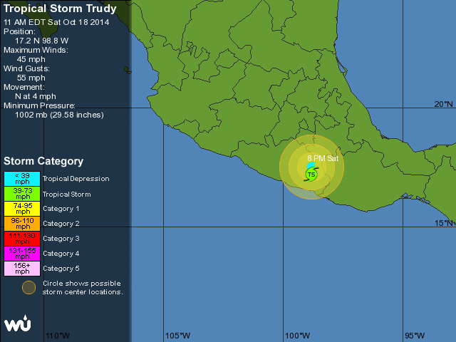
Invest 92E strengthened to tropical storm status last night and this morning has gone ashore 75 miles SE of Acapulco. It will drift slowly while weakening, but it will still generate heavy rains for southern Guerrero and Oaxaca states. I hope they are ready down there...
For us, the blobs it was throwing our way just couldn't make it this far. So our chance of rain is now minimal; just the usual slight chance of PM thunderstorms.
http://www.wunderground.com/hurricane/eastern-pacific/2014/Tropical-Storm-Trudy
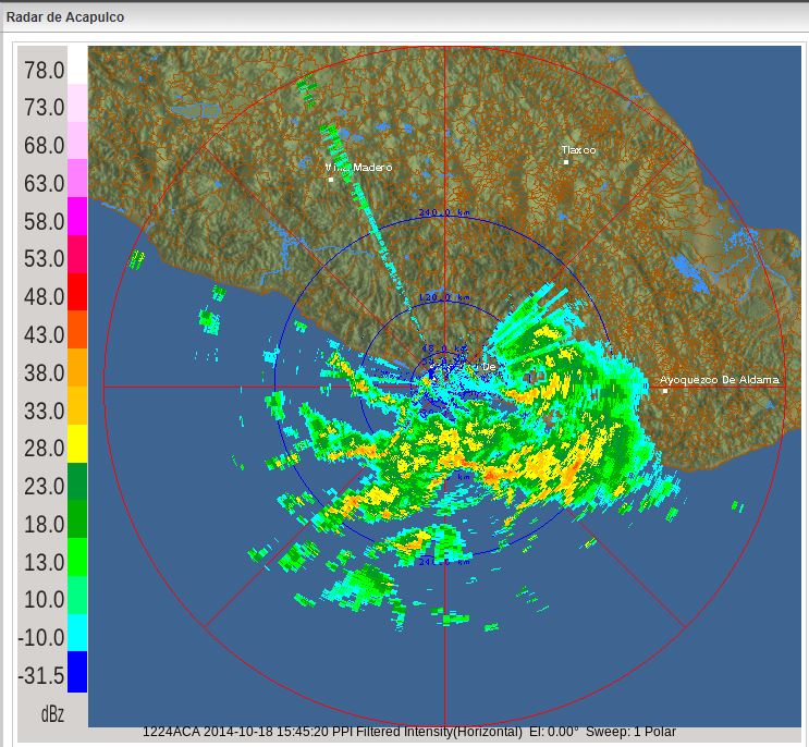
Conagua weather radar from Acapulco showing heavy rain inland:
http://smn.cna.gob.mx/index.php?option=com_content&view=article&id=14&Itemid=84
Excerpt from NHC Public Advisory, warning of very heavy rains and flash flooding down there:
http://www.nhc.noaa.gov/text/refresh/MIATCPEP5+shtml/181143.shtml?
"...RAINFALL...TRUDY IS EXPECTED TO PRODUCE RAINFALL OF 6 TO 12 INCHES WITH ISOLATED AMOUNTS NEAR 20 INCHES DURING THE NEXT FEW DAYS IN THE STATES OF GUERRERO AND OAXACA IN SOUTHERN MEXICO. THESE RAINS ARE EXPECTED TO PRODUCE LIFE-THREATENING FLASH FLOODS AND MUDSLIDES...ESPECIALLY IN AREAS OF MOUNTAINOUS TERRAIN..."
I don't see any more storms developing at least for the next week.
|
-----------------------------
|
|
|
|