Confusing aspect of NHC Tropical Outlook page
Posted by Bret B Re: Confusing aspect of NHC Tropical Outlook page
Posted by Daniel H
![]()
 on October 30, 2014, 11:18 am
187.148.142.164
-----------------------------
In case you use the NHC Eastern Pacific Graphical Tropical Weather Outlook, watch out for a VERY misleading aspect of this page.
Here's this morning's 2-day outlook:
http://www.nhc.noaa.gov/gtwo.php?basin=epac&fdays=2 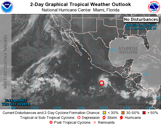
Note that although TD 21-E is shown on the map (red circle to the south of Mexico), the label in the upper right says "NO DISTURBANCES." Their definition of "disturbance" does NOT include tropical cyclones that have already formed (tropical depressions, tropical storms or hurricanes.) They mean only those disturbed areas that MIGHT develop into a cyclone. Sometimes a disturbance might have an Invest number, other times just an "area of interest."
And this morning's 5-day outlook:
http://www.nhc.noaa.gov/gtwo.php?basin=epac&fdays=5 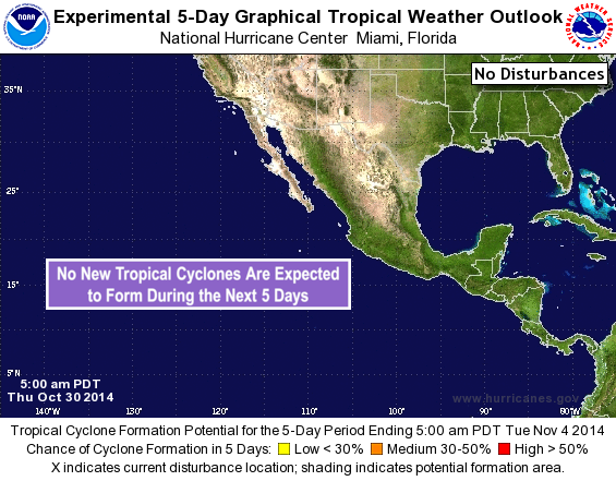
This chart is even more misleading! The map doesn't even show TD 21-E, it says "NO DISTURBANCES" in the upper right, and "NO NEW TROPICAL CYCLONES ARE EXPECTED TO FORM IN THE NEXT 5 DAYS." Did you catch the word "NEW" in that note?
So basically, these two charts are only good for keeping an eye out for areas that MIGHT develop into a cyclone in the next 2 days or the next 5 days. Don't use them to track anything that already has a tropical cyclone designator (like TD 21-E or Tropical Storm Vance, etc.)
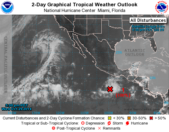
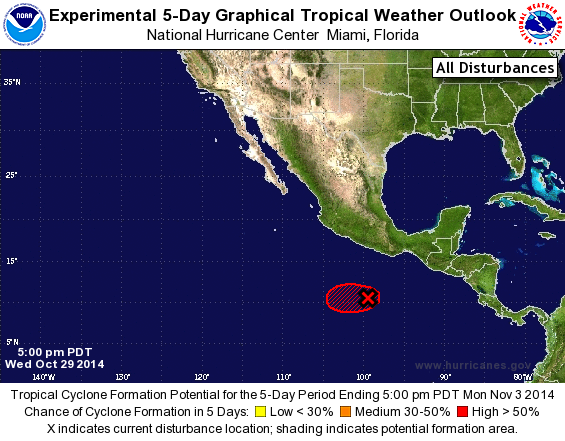
Here are the archived versions from yesterday afternoon, showing the "disturbance" that at the time was called Invest something-or-other. This is what they are good for.
![]() on October 30, 2014, 11:39 am, in reply to "Confusing aspect of NHC Tropical Outlook page"
on October 30, 2014, 11:39 am, in reply to "Confusing aspect of NHC Tropical Outlook page"
201.138.178.170
-----------------------------
Thanks Bret!
For a minute there I was less certain about the uncertainty. 
« Back to index
194