Rain this weekend? and technical discussion
Posted by Bret B  on February 10, 2015, 4:26 pm on February 10, 2015, 4:26 pm
187.148.141.155
We continue to have slightly odd weather for February. These heavy-looking clouds we've been having the last couple days hardly ever produce rain; they are too low-altitude and warm to even show on the IR satellite loops. Just this afternoon they have gotten heavier and colder and are starting to show: http://www.ssd.noaa.gov/goes/west/epac/flash-avn.html
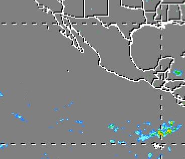
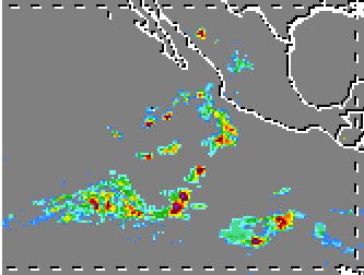
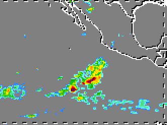
In the last few hours there was no rain within several hundred miles of us according to the TRMM satellite:
But there is a chance of rain in the next few days. I would say maybe 50% chance of light sprinkles, and somewhat less chance of any heavier rain. Anytime from Friday through Monday?
Technical discussion (weather nerds only): 
Weather Underground says only 20%, and no significant accumulation. The rain probability peaks on Friday: http://www.wunderground.com/q/locid:MXJO0760 Of course, their forecast changes significantly hour by hour, which tells me their predictive model is very "noisy".
But the GFS computer model predicts some significant showers all around us Thursday thru Sunday: http://www.hpc.ncep.noaa.gov/mike/gfs/crb_p24i_loop_12.html . If some of these showers shift just a hundred miles closer, we could get an inch or two.
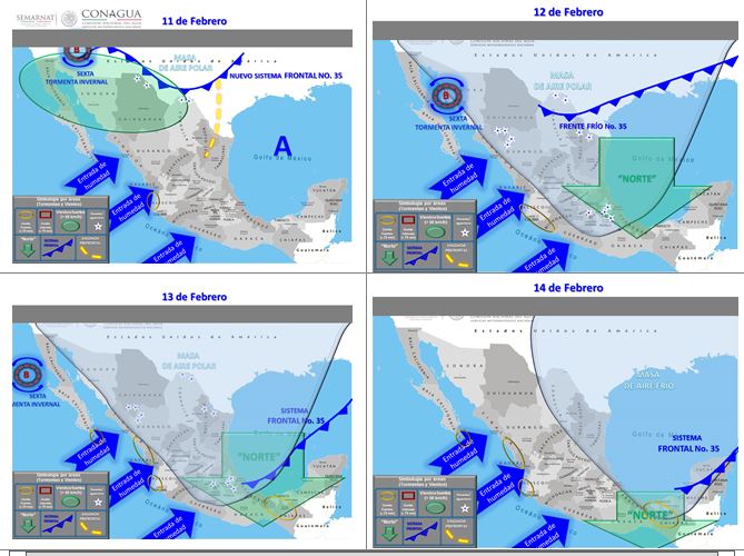
The Mexican SNM weather site's 96-hour technical discussion ( http://smn.cna.gob.mx/index.php?option=com_content&view=article&id=55&Itemid=58 ) is a little hard to read, but they predict a higher chance of rain for our part of the coast. As far as I can translate, they call for up to 1-2 inches of rain in Jalisco every day from tomorrow (Wed) thru Saturday, mostly along the coast. I think this is unlikely, but I thought you should know.
Here is their graphical forecasts for the next 4 days. Sorry they are so tiny; I have never found bigger versions of these 4-day forecast graphs anywhere on their site:
It's too bad that their model viewer is broken except for the WRF-SMN model: http://smn.cna.gob.mx/index.php?option=com_content&view=article&id=16&Itemid=87
They do have a nice narrated one-day video forecast that's non-technical and fairly easy to follow (in Spanish). Look in the lower right corner of this page: http://smn.cna.gob.mx/index.php?option=com_content&view=featured&Itemid=128
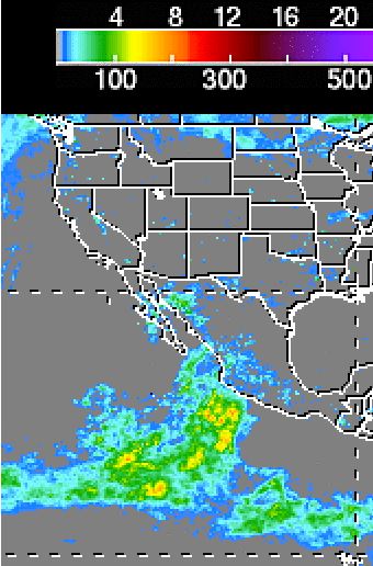
This chance of rain is being caused by conditions similar to last week's rains. You can see some of these factors in the 4 charts above:
1. An upper-level low wandering around Arizona and northern Baja the next few days. (This is causing a winter storm for those poor people up there.) I think this low (and the upper-level trough it's embedded in) helps to divert the jet stream to the south where it picks up that notorious "Pacific moisture" from the Inter-Tropical Convergence Zone (ITCZ), before heading toward us with it.
2. A strong influx of moist Pacific air carried from the southwest by a southern branch of the jet stream (as mentioned above).
3. And I think I can see a surface trough along the Pacific coast in the 4 charts; this may help to "trigger" the moisture to fall out as rain.
The very interesting "earth.nullschool.net" site predicts some of these features also. This snapshot is for Friday the 13th, and shows the upper-level winds at the typical altitude of the jet streams (250hPa/10,500m/35,000ft.) You can see one or two lows spinning counterclockwise near Baja, and the strong southerly jet stream branch: http://earth.nullschool.net/#2015/02/13/2100Z/wind/isobaric/250hPa/orthographic=-106.73,18.46,1542
I'll keep you posted on the forecast, except maybe not tomorrow.
|
------------------------Re: Rain this weekend? and technical discussion
Posted by Bret B on February 10, 2015, 4:33 pm, in reply to "Rain this weekend? and technical discussion"
187.148.141.155
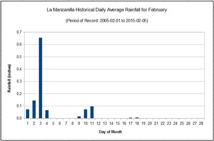
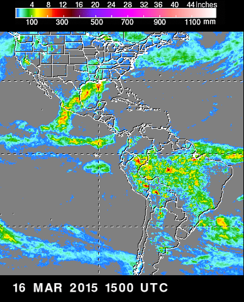
I forgot to include this chart of the historical 10-year average rainfall per day for February. You can see it's not supposed to be a very rainy month:
|
------------------------Re: Rain this weekend? Thursday update
Posted by Bret B on February 12, 2015, 9:52 am, in reply to "Re: Rain this weekend? and technical discussion"
187.148.141.155
Not much change in my forecast from Tuesday: I think there is still a good chance of some sprinkles & light showers from today through Monday or so, with a slight possibility of some heavier rains if the computer models are a little off.
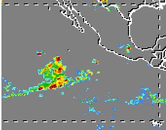
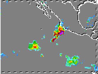
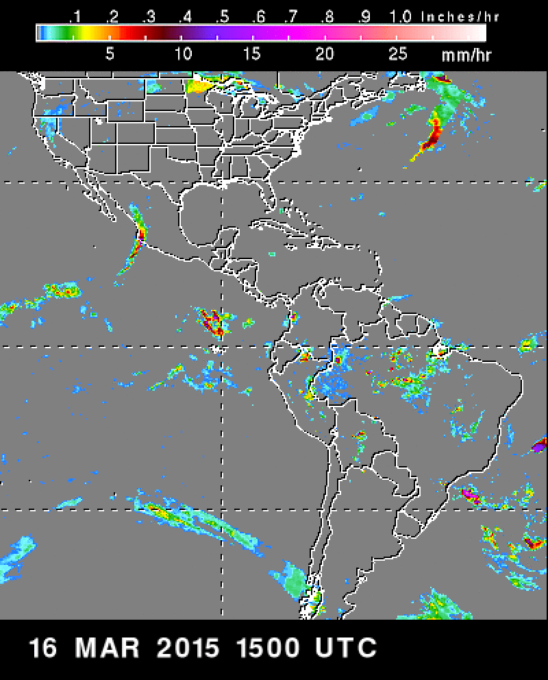
Most of the links in my previous post are still saying about the same thing as before, except the latest TRMM data (0900Z) now shows a large area of rains far (500 miles) to our SW, and an isolated heavy thunderstorm complex quite a bit closer (200 miles.) The TRMM data is up to several hours old, so these rain features have certainly changed by now, but you can see these rains are getting closer.
http://trmm.gsfc.nasa.gov/trmm_rain/americas/americas_3hrly_zoom.gif
Her is an animated view of the last few days of TRMM data, every 3 hours: http://trmm.gsfc.nasa.gov/trmm_rain/americas/americas_3hrly.mpg
It's pretty small, but it covers more of our area of interest than their large animation: http://trmm.gsfc.nasa.gov/trmm_rain/Events/latest_central_america_3hrly_rain.mov
And the NHC Tropical Weather Discussion ( http://www.nhc.noaa.gov/text/refresh/MIATWDEP+shtml/ ) mentions the low pressure well to our SW spinning and triggering the large area of rains mentioned above: "...AN UPPER LEVEL CYCLONE IS SPINNING AT 17N121W WITH UPPER DIFFLUENCE OVER ITS E SEMICIRCLE ENHANCING SCATTERED MODERATE ISOLATED STRONG CONVECTION WITHIN AN AREA BOUNDED BY A LINE FROM 21N120W TO 16N97W TO 08N122W TO 21N120W...." "Upper diffluence over its E semicircle" means the low is causing the high-altitude air to its east to spread out. This creates a suction which lifts lower-altitude air up which makes that low moist air unstable, leading to precipitation.
Next update tomorrow AM.
|
------------------------Re: Rain this weekend? Friday update
Posted by Bret B on February 13, 2015, 9:33 am, in reply to "Re: Rain this weekend? Thursday update"
187.148.141.155
Not much change in the models and forecasts. Maybe the chance of heavier rains is a little less. We'll be somewhere between slightly damp to pretty wet, off and on through Monday or so. Sorry!
Also, the neato swirly-winds website ( http://earth.nullschool.net/#current/wind/surface/level/orthographic=-102.49,15.85,3000 ) says it will be breezy later today from the east.
We've already had at least one little sprinkle this morning. The latest TRMM data ( http://trmm.gsfc.nasa.gov/trmm_rain/americas/americas_3hrly_zoom.gif ) from the last few hours shows the showers were approaching from the SW and spreading out to surround us like they didn't want us to escape their trap or something. Maybe our invisible force field will hold them off (not kidding; that happens frequently):
Until tomorrow...
|
------------------------Re: Rain this weekend? Friday update
Posted by Daniel H on February 13, 2015, 9:37 am, in reply to "Re: Rain this weekend? Friday update"
201.133.153.237
"somewhere between slightly damp to pretty wet"
First time I heard a forecast like that 
Thank you Bret
|
------------------------Re: Rain this weekend! Saturday update
Posted by Bret B on February 14, 2015, 9:00 am, in reply to "Re: Rain this weekend? Friday update"
187.148.141.155
The sprinkles yesterday developed into an actual thunderstorm last night around 10pm, followed by a few showers off and on. As of 8am this morning, we got 0.1" / 2.5mm since yesterday.
Once again, there isn't much change in the various forecasts and computer models. Looks like a continuing chance of occasional light rains today: still about 50% for the day? The IR loop ( http://www.ssd.noaa.gov/goes/west/epac/flash-avn.html ) shows the heavy moisture plume might be tapering off somewhat, later in the day. So hopefully there will be less chance of rain interfering with your Valentine's dinner plans. 
The forecast continues somewhat the same for tomorrow (Sunday), and then tapering off and drying out by Monday night.
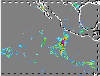
As far as this morning goes, the latest TRMM data (0900Z) shows a large cluster of heavy rains and thunderstorms just off shore from us. Since this data is a few hours old, I don't know what happened to these rains. They might have hit our force field: http://trmm.gsfc.nasa.gov/trmm_rain/americas/americas_3hrly_zoom.gif
|
------------------------Re: Rain this weekend! Sunday update - rain gauge correction
Posted by Bret B on February 15, 2015, 7:49 am, in reply to "Re: Rain this weekend! Saturday update"
187.148.141.155
I don't know what happened yesterday morning; maybe I didn't have my coffee before posting? The rainfall for the 24 hrs ending yesterday (Saturday) at 8AM should have said 0.5" / 12.5mm, NOT 0.1".
Since then we've had nothing but a trace. It turned out to be a decent Valentine's evening, with a spectacular sunset!
My forecast is getting closer to the Weather Underground forecast (they say 20% chance of rain today, but no accumulation.) I would keep the chance a little higher and a little heavier based on the computer models and the continued presence of the stream of heavy moisture still affecting us. You can see on the IR loop that the stream is weakening but still present: http://www.ssd.noaa.gov/goes/west/epac/flash-avn.html
The latest TRMM data showed rains offshore a ways: http://trmm.gsfc.nasa.gov/trmm_rain/americas/americas_3hrly_zoom.gif
Also, the NHC discussion ( http://www.nhc.noaa.gov/text/refresh/MIATWDEP+shtml/ ) mentions this feature and uses the more "technical" name for it: "...A TONGUE OF MOISTURE IS FORECAST TO PERSIST ALONG THE WEST COAST OF MEXICO ROUGHLY FROM WESTERN GUERRERO TO NAYARIT THROUGH MONDAY." Must be some kind of Valentine's terminology 
So I'd say maybe 30% chance of something measurable today, tapering off to nothing by late Monday. As always when we are surrounded by heavier rains, there is a slight chance that our force field could let something through and give us an inch or two.
|
------------------------Re: Rain this weekend! Monday update and storm totals
Posted by Bret B on February 16, 2015, 9:57 am, in reply to "Re: Rain this weekend! Sunday update - rain gauge correction"
187.148.141.155------------------------Re: Rain done for now. Breezy today?
Posted by Bret B on February 17, 2015, 8:19 am, in reply to "Re: Rain this weekend! Monday update and storm totals"
187.148.141.155
I'm calling this one over with. Nothing new in the rain gauge since yesterday morning. There are still some clouds streaming over us today, but quite a bit higher, drier and thinner.
One thing we can expect today is stronger breezes from the NW or W. Much better for sailing in the bay than those sporadic breezes from the SE and S we've been having. The forecasts range from 10-20 mph, mostly in the afternoon. Bring your kites on the beach!
I'll try to keep an eye out for any more moist air down in the ITCZ getting caught up in the "tongue", and coming our way threatening more rain. This overall pattern seems to be persistent...
|
------------------------
|
|
|
|
|
|
|
|
|