Posted by Bret B
![]()
 on April 29, 2015, 9:09 pm, in reply to "Re: Weather map, yikes"
68.0.180.159
I just got a chance to check the weather in between activities up here. Thanks for posting the heads-up, Judy.
It looks like the 300-500 mile vicinity of La Manz is settling down this afternoon, but there is quite a bit of strong convection (thunderstorms) down in the hurricane breeding grounds. I don't think the conditions are conducive to forming hurricanes and sending them westward or northwestward, yet. Too much wind shear, etc. In addition to the "hidden" composite IR loop that Judy showed, the western Atlantic view from the GOES-East IR satellite is a good way to see the breeding grounds south of Central Americal and southern Mexico: http://www.ssd.noaa.gov/goes/east/watl/flash-avn.html 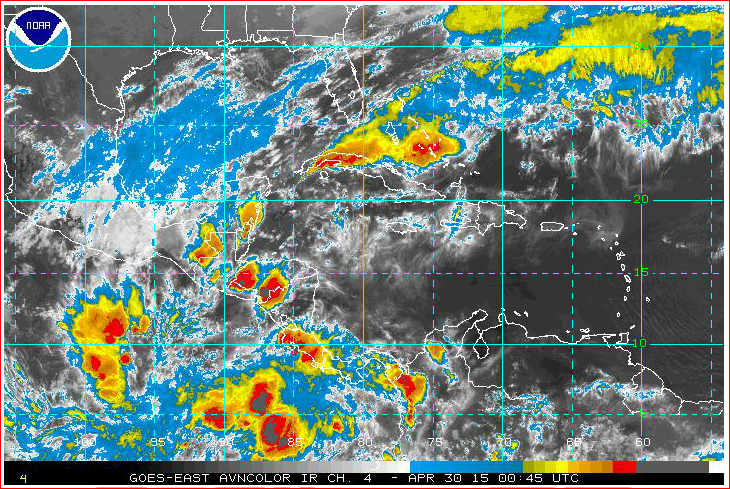
The soon-to-reenter TRMM radar satellite shows that a few hours ago the closest rain to La Manz was a few tiny showers several hundred miles to the SW: http://trmm.gsfc.nasa.gov/trmm_rain/americas/americas_3hrly_zoom.gif 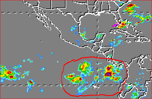
(I circled the area I call the "Breeding Grounds" in red.)
The NHC hurricane tracking team isn't back on duty until May 15, but here is a even more technical than normal excerpt from the East Pac Tropical Wx Discussion ( http://www.nhc.noaa.gov/text/refresh/MIATWDEP+shtml/ ):
"A VERY ENERGETIC UPPER LEVEL PATTERN DOMINATES THE DISCUSSION AREA N OF THE ITCZ AND 15N THIS AFTERNOON TO 100W AND MEXICO. A SERIES OF TROUGHS CAN BEEN SEEN IN WATER VAPOR IMAGERY MOVING GENERALLY EASTWARD...EMBEDDED IN THE WESTERLY FLOW ALOFT. A VIGOROUS MIDDLE TO UPPER TROUGH IS ALONG 108-110W FROM THE S END OF BAJA CALIFORNIA TO 12N108W...AND SHIFTING EWD INTO MEXICO. THIS TROUGH WILL CONTINUE EASTWARD AND LIFT OVER THE DOWNSTREAM UPPER RIDGE CENTERED OVER THE W CARIBBEAN. THIS IS PRODUCING A ZONE OF STRONG UPPER LEVEL DIVERGENCE ACROSS THE TROPICS E OF 100W WHERE VERY DEEP CONVECTION CONTINUES ABOUT THE MONSOON TROUGH THERE. COMPUTER MODELS SUGGEST THAT THIS AREA WILL REMAIN VERY UNSTABLE AND ACTIVE WITH CONVECTION THROUGH THURSDAY BEFORE SHIFTING SLOWLY EWD FRI AND SAT."
In the same discussion was this high surf forecast. This might affect La Manz more than the wild "blobs" roaming around out in the breeding grounds. Be safe if the waves get big!
"LOOKING AHEAD...LARGE LONG PERIOD SW SWELL GENERATED FROM A VERY LARGE STORM SYSTEM ACROSS THE SE PACIFIC A FEW DAYS AGO WILL BEGIN TO MOVE N AND NE INTO THE REGIONAL WATERS THU AND THU NIGHT AND REACH THE CENTRAL AMERICAN AND MEXICAN COAST SAT TO PRODUCE VERY LARGE AND DANGEROUS WAVES ACROSS THE COASTAL ZONES...FROM PANAMA TO BAJA CALIFORNIA. A SMALLER PRE CURSOR PULSE OF THIS SW SWELL WILL ARRIVE ALONG THE COASTS FRI AND BE OVERTAKEN ON SAT."
244
Message Thread
![]()
« Back to index | View thread »