Posted by Bret B
![]()
 on June 26, 2015, 10:38 am
189.164.203.102
Anyone else getting a little tired of the heat and want something to break it up? We have had no rain since the 3.9" on the 17th, and the afternoon highs have been running about 94°F/34°C with RH values in the upper 50% range. This yield a heat index of around 109°F/43°C. Time for a break!
For several days now, the Weather Undergound forecast for Barra de Navidad has been predicting some thunderstorms with rainfall accumulations of around 1/2" on Sunday and Monday: http://www.wunderground.com/q/locid:MXJO0760
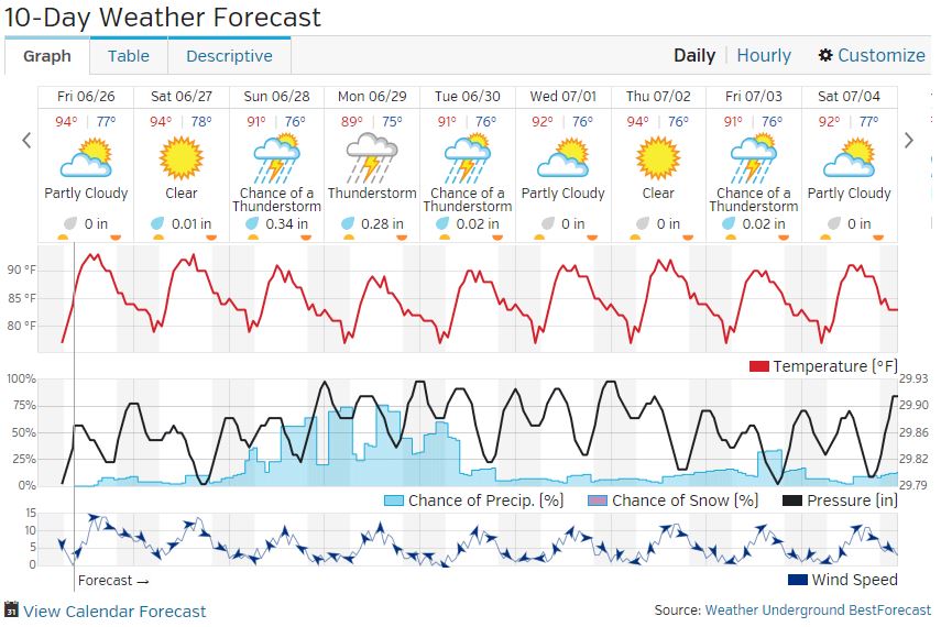
Until today I wasn't able to find a believable cause of such a steady long-range rain forecast. It was not a tropical storm developing (no such activity lately.) But now it looks like the cause is one of the steady parade of "tropical waves" ( http://en.wikipedia.org/wiki/Tropical_wave ) that have been passing to our south, from east to west. None of these have affected us in the last several days, but this weekend one is predicted to sweep across our part of Mexico. That may be enough of a trigger to bring us some rain and hopefully a bit of a cool-down.
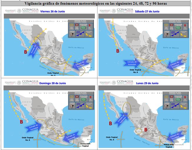
The Mexican weather forecasters track and number these waves. They call this one "onda tropical #8." Their very wordy and difficult-to-read daily discussion has some tiny forecast maps for the next three days showing this wave approaching us on Saturday (tomorrow) and passing us on Sunday. They predict 1-2" of rain somewhere in Jalisco on Saturday, Sunday and Monday. Rainfall amounts here on the coast are usually much less, but there is still hope!
Mexican weather discussion (updated daily around 1:00PM CDT, in Spanish): http://smn.cna.gob.mx/boletin/discusion/discusion.html
The forecast maps that show this wave (almost too tiny to read):
507
Message Thread
![]()
« Back to index | View thread »