Posted by Bret B
![]()
 on September 27, 2015, 10:22 am
70.190.168.128
Here's a heads-up before I go offline again in a few days. Tropical Storm Marty earned its name just last night, and is threatening a large section of the Pacific coast of Mexico with heavy rains because of its large size and slow movement. La Manz is not in the direct path, but this one is being hard to predict.
A Tropical Storm Watch has been issued for the coast as far north as Lazaro Cardenas (in the southern part of Michoacán.)
From the Public Advisory ( http://www.wunderground.com/hurricane/eastern-pacific/2015/Tropical-Storm-Marty?text=public&MR=1 ) (note the heavy rainfall predictions at the end):
"A tropical storm watch is in effect for...
* Acapulco, Mexico to Lazaro Cardenas, Mexico
A tropical storm watch means that tropical storm conditions are possible within the watch area, generally within 48 hours.
Discussion and 48-hour outlook
------------------------------
at 1000 am CDT (1500 utc), the center of Tropical Storm Marty was located near latitude 14.9 north, longitude 102.8 west. Marty is moving toward the north-northeast near 7 mph (11 km/h). A turn toward the northeast and a decrease in forward speed are expected tonight and Monday. On the forecast track, the center of Marty is forecast to approach but remain offshore the southwestern coast of Mexico.
Maximum sustained winds are near 60 mph (95 km/h) with higher gusts. Strengthening is expected during the next 24 hours, and could become a hurricane by tonight. Weakening is expected to begin Monday night.
Tropical storm force winds extend outward up to 80 miles (130 km) mainly to the east of the center.
Hazards affecting land
----------------------
wind: tropical storm conditions are possible within the watch area by Monday night.
Rainfall: Marty is expected to produce rainfall amounts of 4 to 6 inches with isolated maximum amounts of up to 10 inches across the Mexican state of Guerrero through Tuesday. These rains are expected to produce life-threatening flash floods and mudslides, especially in areas of mountainous terrain."
-----------------------------------------------
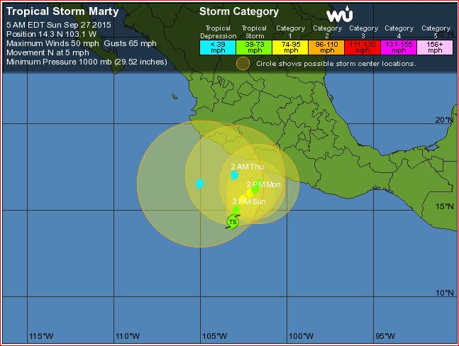
Here is the 5-day track prediction: note the large error circles; the center can be anywhere in those circles.
http://www.wunderground.com/hurricane/eastern-pacific/2015/Tropical-Storm-Marty?map=5day
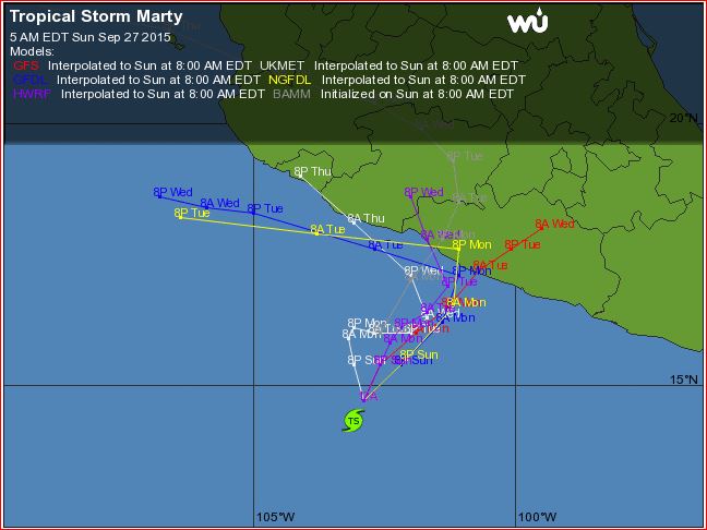
Here are the various computer models: not much agreement after Monday/Tuesday:
http://www.wunderground.com/hurricane/eastern-pacific/2015/Tropical-Storm-Marty?map=model
Keep an eye on Marty. I might not be able to post any more reports.
PS, this time of year the storm tracks start to become erratic and hard to predict, and prone to making sudden right turns into the coast (like Jova in October 2011...)
787
Message Thread
![]()
« Back to index | View thread »