Posted by Bret B
![]()
 on September 28, 2015, 9:10 am, in reply to "TS Marty: heavy rain threat to Mexican coast"
70.190.168.128
Not much change in Marty's forecast: still a heavy rainmaker for parts of the coast and a very uncertain track forecast. The Public Advisory has almost doubled the rainfall accumulation forecast for Guerrero:
"Marty is expected to produce rainfall amounts of 6 to 12 inches over the Mexican state of Guerrero through Thursday, with isolated amounts near 20 inches from the Sierra Madre del Sur mountains toward the coast. These rains are expected to produce life-threatening flash floods and mud slides, especially in areas of mountainous terrain."
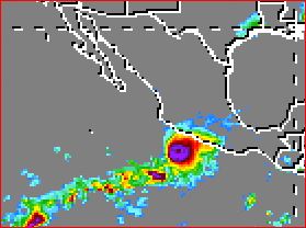
This is the most forecast rain I have ever seen from the NHC. However, it looks like the heaviest rains are currently heading toward Michoacán, not Guerrero. The huge blob is already visible in the Mexican IR loop:
http://smn.cna.gob.mx/satelite/goesE/co/loop.gif
And here is the latest snapshot from the TRMM site ( http://trmm.gsfc.nasa.gov/trmm_rain/americas/americas_3hrly_zoom.gif ):
I might not be able to post any more updates. Just use these links or your own favorites to keep an eye on Marty.
184
Message Thread
![]()
« Back to index | View thread »