rain and lightning
Posted by Daniel H  on July 12, 2015, 9:17 pm on July 12, 2015, 9:17 pm
Edited by board administrator July 12, 2015, 9:35 pm
Got some rain this afternoon, nice.
There is some lightning happening off the coast
http://www.lightningmaps.org/realtime
It is quite accurate, I can see a lightning strike and it shows up on the
map pretty much at the same time. You can zoom in to see just our (or your) area.
I left the cam on for a while. Its not a great show but still a little first.
http://lamanzanilla.info/web_cam.html
Kind of dropping off now, perhaps again the next time there is a light show.
There is another cell moving up the coast, perhaps it will bring some stuff.
Looks like its starting to spin. Bret you around?
http://www.ssd.noaa.gov/PS/TROP/DATA/RT/epac-ir4-loop.html
Use zoom or ctrl + to make the cam screen bigger. |
------------------------Tropical Storm DOLORES
Posted by Daniel H on July 12, 2015, 9:39 pm, in reply to "rain and lightning"
187.148.187.72------------------------Re: Tropical Storm DOLORES
Posted by Deanna on July 13, 2015, 8:59 am, in reply to "Tropical Storm DOLORES"
187.147.11.75------------------------Re: Tropical Storm DOLORES
Posted by Bret B on July 13, 2015, 11:31 am, in reply to "Re: Tropical Storm DOLORES"
201.133.154.98
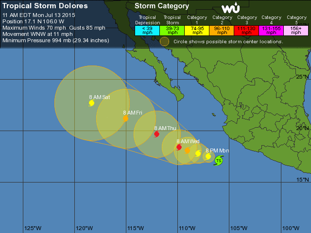
Hi guys, sorry for the very erratic weather reporting lately. Here's a quick update on Dolores, but I'll be offline most of the next 3 days, so don't rely on my reports for important info:
It's passing us today and tonight, well offshore (170 miles to our SW.) It's predicted to strengthen to a Cat 1 hurricane by tonight, and peak at Cat 3 by Wednesday far to our WNW:
http://www.wunderground.com/hurricane/eastern-pacific/2015/Tropical-Storm-Dolores?map=5day&MR=1
Here is the GOES IR satellite loop that stays zoomed-in and centered on Dolores (AKA "Dolores Long Floater - no kidding!):
http://www.ssd.noaa.gov/PS/TROP/floaters/05E/flash-avn-long.html
You can see the huge angry-looking "blob" that is Dolores. Although it looks very threatening for La Manz right now, the outer edge of these kinds of blobs usually doesn't drop much rain. We might get a little rain today directly from Dolores, and maybe some more in the next couple days from the indirect effects (moisture being imported by the low pressure of Dolores as it passes.)
The NHC Public Advisory says that the Tropical Storm Watch still covers our part of the coast, and warns about the possibility of winds, rains and waves:
http://www.nhc.noaa.gov/text/refresh/MIATCPEP5+shtml/131445.shtml?
Excerpts:
"A Tropical Storm Watch is in effect for...
* Punta San Telmo to Cabo Corrientes
A Tropical Storm Watch means that tropical storm conditions are possible within the watch area, in this case within the next 12 hours."
"WIND: Tropical storm conditions are possible within the watch area through early this afternoon.
RAINFALL: The outer rain bands of Dolores are expected to produce total rain accumulations of 1 to 3 inches along the southwestern coast of Mexico from the state of Michoacan to Jalisco. Isolated maximum amounts of 5 inches are possible.
SURF: Swells generated by Dolores are expected to affect the southern and southwestern coasts of Mexico and the Baja California peninsula during the next few days, and could cause life-threatening surf and rip current conditions."
So enjoy the cooler weather and whatever rains we get!
|
------------------------
[ La Manzanilla Message Board ]
|
|
|
|