 on September 2, 2014, 1:41 pm, in reply to "Re: Invest 93E: heavier rains this week?"
187.148.187.54
|
Tropical Storm Norbert just got its name this morning, barely. It's only blowing at 40 mph near the center. At our distance (currently about 170 miles) we shouldn't get more than gusty breezes. Norbert might not make it to full hurricane strength anytime soon. However, it has plenty of moisture to play with. Our storm total is 2.54" / 65mm so far and I would expect a fair bit more over the next few days. Wunderground's forecast for Barra de Navidad only mentions a 1" accumulation: http://www.wunderground.com/q/locid:MXJO0760 . The Mexican ConAgua site warns of heavy rain rates of 30mm-60mm (1.2"-2.4") per hour along the Jalisco coast, but they don't mention total accumulations: http://smn.cna.gob.mx/boletin/especial/severo.html. The US NWS Weather Prediction Center's Caribbean page (also includes Mexico) shows a more detailed (somewhat complicated to interpret) rainfall accumulation prediction for the next week. In this one, we will be on the edge of a heavy rain zone just offshore that peaks at a few inches per 24-hr period: http://www.hpc.ncep.noaa.gov/mike/gfs/crb_p24i_loop_12.html This site ( http://wxmaps.org/pix/prec3.html ) shows a total accumulation over the next 7 days of 250mm (10"!), centered just offshore of us. This site has not been super-accurate in the past so don't panic about that 10". Here's the predicted track showing closest approach tonight (maybe 160 miles from us), then turning away from us toward the NW: http://www.wunderground.com/hurricane/eastern-pacific/2014/Tropical-Storm-Norbert?map=5day 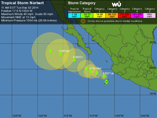 PS, there are NO coastal watches or warnings in effect. |
| 173 |
|
Message Thread
|
|
|