Posted by Bret B
![]()
 on March 19, 2015, 2:04 pm, in reply to "Rain Forcast for March 18 to 28 ?"
187.148.43.133
(Lately I've been delaying my forecasts until after 12:00 noon, when the Mexican CONAGUA site releases their daily report.)
Combining all my online weather resources along with my guesswork, my rain forecast for the next 3-4 days looks about the same as in yesterday's post: slight chance (20%) of light rains for tomorrow and Saturday. Sunday & Monday look drier: less than 10%?
Short-term forecast for the rest of today: medium chance (30-40%?) of sprinkles or light showers. This is supported by the thickening cloudiness streaming closer and closer to us today visually (as in Mark's Weather Right Now), and on the IR loop ( http://www.ssd.noaa.gov/goes/west/epac/flash-avn.html ).
And the latest TRMM rainfall data from a few hours ago (1500Z) shows showers that were thickening and joining up in a line that was slowly edging closer to us. The main showers were about 120 miles away in this data, but some lighter rains were already reaching the coast near PV: ( http://trmm.gsfc.nasa.gov/trmm_rain/americas/americas_3hrly_zoom.gif ) 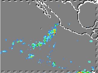
My guesswork is worth about what you pay for it; remember that last week my rain total forecast was 5-10 times too low 
More tomorrow, if I have time...
148
Message Thread
![]()
« Back to index | View thread »