 on September 17, 2014, 12:29 pm, in reply to "Re: Manzanillo outlook"
201.138.178.248
|
The latest update from the NHC shows Polo's predicted track staying offshore, but it'll be close enough to reach out and give us some winds and rains. So the Mexican government has raised our alert status from Tropical Storm Watch to Tropical Storm Warning. The warning area extends from Michoacán well to our south to Playa Perula a little to our north. NHC Public Advisory: http://www.nhc.noaa.gov/text/refresh/MIATCPEP2+shtml/171454.shtml? Excerpt: "A TROPICAL STORM WARNING MEANS THAT TROPICAL STORM CONDITIONS ARE EXPECTED SOMEWHERE WITHIN THE WARNING AREA...IN THIS CASE WITHIN 24 HOURS." They also give an estimated rainfall prediction, a little higher than my educated guess earlier this morning: "RAINFALL...POLO IS EXPECTED TO PRODUCE TOTAL RAINFALL AMOUNTS OF 5 TO 10 INCHES WITH ISOLATED TOTALS OF 15 INCHES NEAR THE COAST OF MICHOACAN...COLIMA...AND JALISCO STATES IN MEXICO. THESE RAINS COULD RESULT IN LIFE-THREATENING FLASH FLOODS AND MUD SLIDES." Latest tracking map showing that the center staying offshore about 100-120 miles from La Manz as it passes by as a Cat 1 hurricane tomorrow (Thursday): http://www.wunderground.com/hurricane/east-pacific/2014/tropical-storm-Polo?map=5day 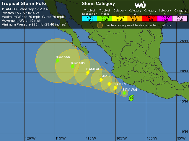 Our chance of getting tropical storm force winds is a little higher now: 50-60%. |
| 167 |
|
Message Thread
|
|
|