RAIN?
Posted by daniel c  on June 29, 2014, 10:31 pm on June 29, 2014, 10:31 pm
98.232.59.204-----------------------------Re: RAIN? and TS Elida - Tropical Storm Warning
Posted by Bret B on June 30, 2014, 10:37 am, in reply to "RAIN?"
201.138.176.170
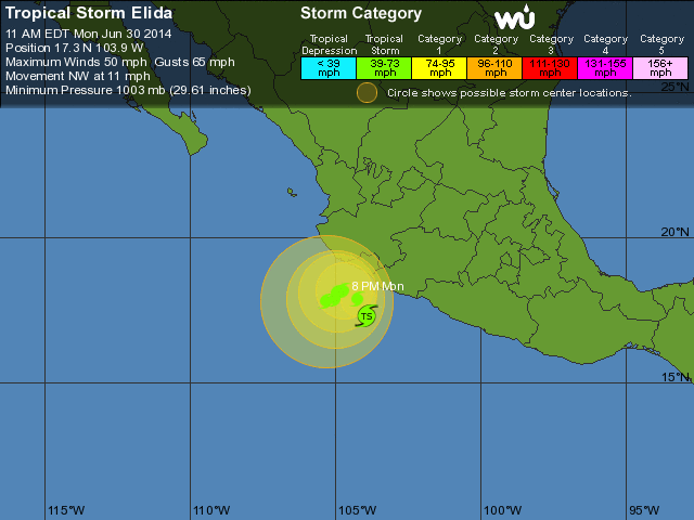
I think you might be right Daniel. Just a couple minutes ago Invest 97E was upgraded to Tropical Storm Elida, and its center was re-analyzed to be quite a bit closer to the Michoacán coast. It's predicted to get a little closer to the Colima coast then slow down and wander for a couple days then head off to the west, remaining a tropical storm. We may get tropical storm force winds (NHC says 50% chance for our location), and probably will get heavy rains, possibly starting later today.
TROPICAL STORM WARNING (warning area includes La Manzanilla):
(Excerpt from NHC Public Advisory( http://www.nhc.noaa.gov/text/refresh/MIATCPEP5+shtml/301444.shtml? ):
"...NEW TROPICAL STORM FORMS OFFSHORE OF THE SOUTHWESTERN COAST OF MEXICO...
...TROPICAL STORM WARNING ISSUED..."
"THE GOVERNMENT OF MEXICO HAS ISSUED A TROPICAL STORM WARNING ALONG THE SOUTHWESTERN COAST OF MEXICO FROM LAZARO CARDENAS TO CABO CORRIENTES."
"HAZARDS AFFECTING LAND
----------------------
WIND...TROPICAL STORM CONDITIONS ARE AFFECTING PORTIONS OF THE SOUTHWESTERN COAST OF MEXICO IN THE WARNING AREA. THESE CONDITIONS ARE EXPECTED TO EXPAND NORTHWESTWARD IN THE WARNING AREA DURING THE NEXT DAY OR TWO.
RAINFALL...ELIDA IS EXPECTED TO PRODUCE TOTAL RAIN ACCUMULATIONS OF 3 TO 6 INCHES OVER THE WESTERN PORTIONS OF THE MEXICAN STATES OF COLIMA AND MICHOACAN...AND OVER THE SOUTHWEST PORTION OF JALISCO. ISOLATED MAXIMUM AMOUNTS OF 8 INCHES ARE POSSIBLE IN THESE AREAS.
SURF...SWELLS GENERATED BY ELIDA ARE AFFECTING PORTIONS OF THE SOUTHWESTERN COAST OF MEXICO. THESE SWELLS ARE LIKELY TO CAUSE LIFE-THREATENING SURF AND RIP CURRENTS. FOR MORE INFORMATION...
PLEASE CONSULT PRODUCTS FROM YOUR NATIONAL METEOROLOGICAL OFFICE."
Here's the predicted track. Note the large circles of uncertainty denoting the probable locations of the storm center:
http://www.wunderground.com/hurricane/eastern-pacific/2014/Tropical-Storm-Elida?
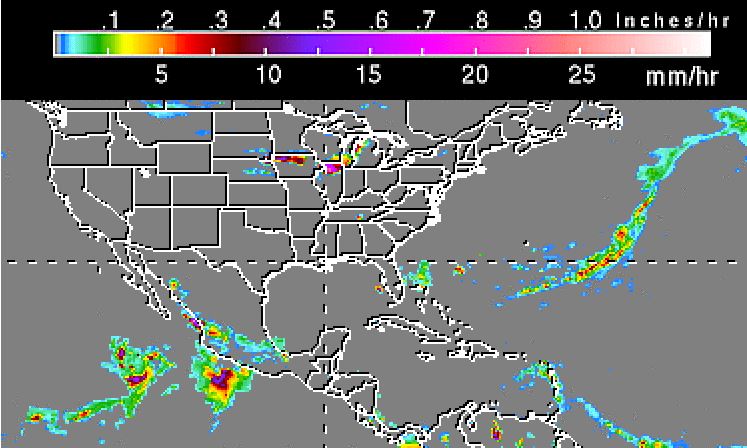
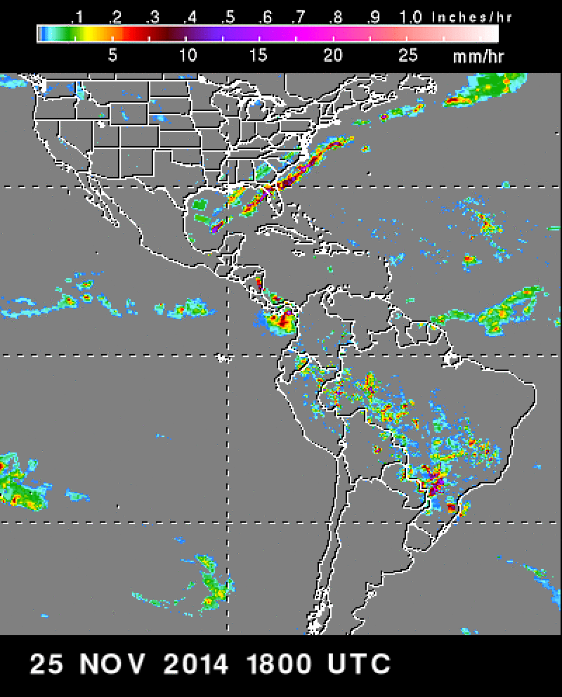
Here's the latest TRMM satellite rain radar data from a few hours ago showing the heavy rains in TS Elida to our south: http://trmm.gsfc.nasa.gov/trmm_rain/americas/americas_3hrly_zoom.gif
|
-----------------------------Re: TS Elida and rain report
Posted by Bret B on July 1, 2014, 8:56 am, in reply to "Re: RAIN? and TS Elida - Tropical Storm Warning"
201.138.176.170
Yesterday it started raining moderately around 4PM and continued past 10PM. I measured 1.52" from that, plus 0.46" earlier before dawn. 24-hr total: 1.98". Nothing in the gauge this morning since midnight.
2 reports from Melaque (Tomzap forum post: http://69.73.170.179/ph5/read.php?12,154777 you might need to log in to read it ): 4.9" and 7.5" (!)
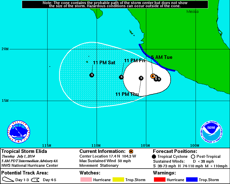
Location: Tropical Storm Elida is wandering slowly and hardly moving for the next couple days. The center is staying offshore to our south but it's close enough to bring us more rain over the next couple days at least.
Rains: The NHC is forecasting 1-3" for the storm total for our coast, with isolated amounts of 5" possible. We already got 1.5-2" of this, but we should be prepared for more, possible a lot more. Luckily, so far the heaviest rains in the core of the storm have been getting blown away from us toward the SE by high altitude winds. This wind shear is the main reason this storm won't get much stronger.
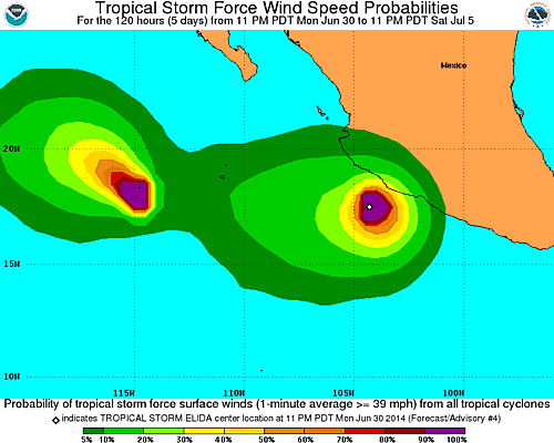
Winds: The chance of strong winds here in La Manz is less now: down to 10-20% chance of getting tropical storm force winds (39-73 MPH.) We are still under a Tropical Storm Warning.
Surf: And of course watch for dangerous surf and currents if you go in the water. How are the waves, Daniel?
NHC page for TS Elida (this shows the TS Warning extent, Wunderground doesn't):
http://www.nhc.noaa.gov/refresh/graphics_ep5+shtml/113610.shtml?5-daynl?large#contents
NHC Public Advisory: ( http://www.nhc.noaa.gov/text/refresh/MIATCPEP5+shtml/011135.shtml? ):
"...ELIDA MEANDERING OFFSHORE OF THE SOUTHWESTERN COAST OF MEXICO WITH LITTLE CHANGE IN STRENGTH..."
TS-force wind probabilities map:
http://www.nhc.noaa.gov/refresh/graphics_ep5+shtml/113610.shtml?tswind120#contents
|
-----------------------------Re: TS Elida - news & photos
Posted by Bret B on July 1, 2014, 10:57 am, in reply to "Re: TS Elida and rain report"
201.138.176.170
Here's some brief news articles and photos of the flooding yesterday in Cihuatlan, Jaluco and Melaque: http://canal235.com/
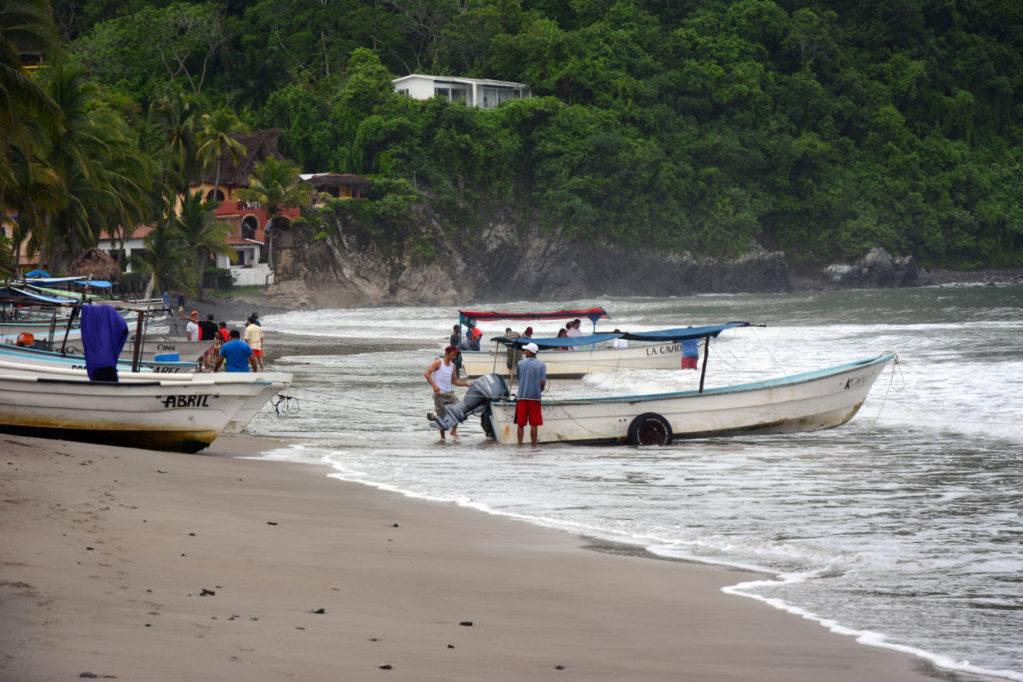
I don't have any reports on street conditions or rios, but here are my shots of the La Manz beach this morning:
Not very wavy, no winds...
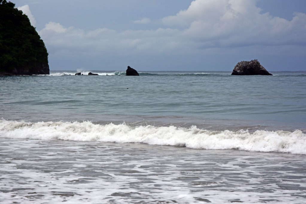
The beach isn't very rocky or eroded yet. No swimmers...

A group of Mexican visitors hired a couple lanchas to go out (to Tenecatita?) They may get wet and queasy today...
|
-----------------------------It Got Wavy
Posted by Mark S. on July 1, 2014, 4:09 pm, in reply to "Re: TS Elida - news & photos"
187.146.131.28
Went down this afternoon to bodysurf, and the swell was a solid 4-6 feet. Not being the young man I used to be, I merely swam under the breakers.
I watched two boats coming in and didn't have a clue as how they would make it. Turns out that they came in stern first, which I would never have thought of.
It's raining pretty constantly, but the weather is cool. Thanks.
|
-----------------------------Re: Elida gone
Posted by Bret B on July 2, 2014, 9:41 am, in reply to "Re: TS Elida and rain report"
201.138.176.170
Elida has been downgraded to a remnant low. It's been pretty much torn apart by the high altitude wind shear coming from the NW.
We got another 0.6" since last night. I really think most of the rain in the last few days was not directly caused by Elida. The clouds and showers seemed to be moving down the coast from the north (opposite direction from Elida.) There is still some of that same action going on this morning, so expect some more light rain today.
See what I mean on the GOES IR satellite loop: http://www.ssd.noaa.gov/goes/west/epac/flash-avn.html
|
-----------------------------
|
|
|
|
|
|