 on September 29, 2014, 11:29 am
187.148.175.45
|
We sure have gone back to the summertime routine lately. The afternoons have been warm (90-91°F/32-33°C), humid (68-72%) and cloudy. That works out to a respectable heat index ("feels like") of 107-109°F/41-43°C. The evenings have been full of distant lightning storms. One grazed us this morning around 2AM, giving us 0.22"/6mm. The last couple days there have been numerous strong thunderstorm "blobs" travelling up the coast at us. They have been just barely missing us offshore a bit. This morning's loop is a good example: http://www.ssd.noaa.gov/goes/west/epac/flash-avn.html We could get quite a downpour if any of these blobs gets better aim... Tropical storm outlook for this week: Invest 90E is slowly trying to get organized down south of Oaxaca/Chiapas. It's got a 70% chance of becoming some kind of cyclone in the next 5 days. The computer models show it passing by us around Thursday and Friday, possibly fairly close offshore. We'll have to keep an eye on the heavy rain possibilities from this one. NHC graphical outlook: http://www.nhc.noaa.gov/gtwo.php?basin=epac&fdays=5 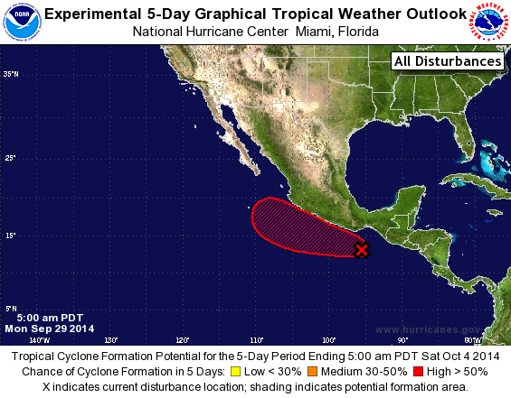 Weather Underground computer models (a little out of date, from last night's run): http://www.wunderground.com/hurricane/east-pacific/2014/invest-90E?map=model 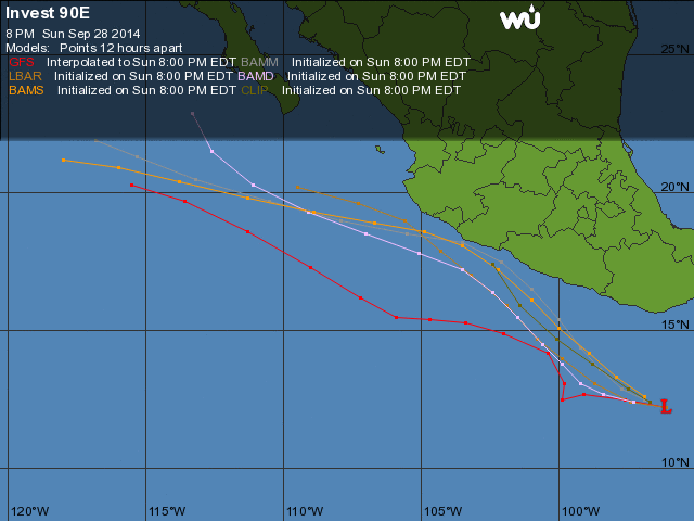 Excerpt from Jeff Master's tropical weather blog regarding Invest 90E: http://www.wunderground.com/blog/JeffMasters/comment.html?entrynum=2813 "Another area of disturbed weather (Invest 90E) was located near the coast of southern Mexico on Monday morning, and was headed slowly west-northwest to northwest. This disturbance has good support from all three of our top tropical cyclone genesis models to develop late this week. In their 8 am EDT Monday Tropical Weather Outlook, NHC gave 90E 2-day and 5-day odds of development of 20% and 70%, respectively. 90E is a threat to bring heavy rains to the Pacific coast of Mexico throughout the week." The area of heavy rains he mentions might not include ALL of the Mexican Pacific coast. Chiapas, Oaxaca, Guerrero would be the main targets, at least at first. The NHC Tropical Weather Discussion (http://www.nhc.noaa.gov/text/refresh/MIATWDEP+shtml/) says "southern Mexico": "...THIS SYSTEM COULD PRODUCE LOCALLY HEAVY RAINS OVER PORTIONS OF SOUTHERN MEXICO THAT COULD CAUSE FLASH FLOODS AND MUD SLIDES. " None of my paltry few rainfall prediction resources shows a high chance of heavy rains for us this week. More to come as it develops... |
| 779 |
|
Message Thread
|
|
|